IMAGES TAKEN NEAR TO
East Lulworth, WAREHAM, BH20 5QT
Introduction
This page details the photographs taken nearby to BH20 5QT by members of the Geograph project.
The Geograph project started in 2005 with the aim of publishing, organising and preserving representative images for every square kilometre of Great Britain, Ireland and the Isle of Man.

There are currently over 7.5m images from over14,400 individuals and you can help contribute to the project by visiting https://www.geograph.org.uk
Image Map
Images are licensed for reuse under creativecommons.org/licenses/by-sa/2.0
Notes
- Clicking on the map will re-center to the selected point.
- The higher the marker number, the further away the image location is from the centre of the postcode.
Image Listing (19 Images Found)
Images are licensed for reuse under creativecommons.org/licenses/by-sa/2.0
Image
Details
Distance
1
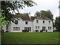
The Lindens
Now a holiday let, it was previously used as a field centre for Bournemouth University.
Image: © Chris Andrews
Taken: 9 Oct 2011
0.01 miles
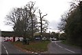
2
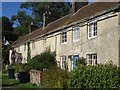
Mount Pleasant Cottages
These cottages were built in 1793 after the clearing of much of the old village centre between 1753 and 1785. At that time the road led over Common Hill to Botany Farm. Since the cemetery down the lane opened in 1862 it has become sometimes known as Cemetery Hill.
Image: © Natalia A McKenzie
Taken: 7 Oct 2006
0.03 miles
3
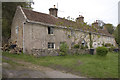
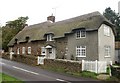
Cottages at East Lulworth
The cottages are in a part of the village known as Mount Pleasant
Image: © John Lamper
Taken: 9 May 2006
0.03 miles
4
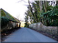
Lulworth Castle Estate Wall and Old Barns.
The old barns on the minor road from Coombe keynes to East Lulworth are opposite a section of the estate wall which has started to crumble.
Image: © Nigel Mykura
Taken: 2 Feb 2013
0.04 miles
5
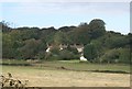
Mount Pleasant & Common Hill
Looking across the Higher Newnhams to Mount Pleasant and Common Hill. There is a Roman Catholic Cemetery on Common Hill.
Image: © Natalia A McKenzie
Taken: 7 Oct 2006
0.10 miles
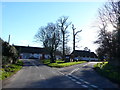
6
East Lulworth
East Lulworth to Coombe Keynes and Wool
Image: © Peter Elsdon
Taken: 1 Nov 2009
0.11 miles
7
Cottages opposite the lane to Cockles
These cottages on the B3070 at East Lulworth face the raised triangle of land and the lane beside it leading down to Cockles.
Image: © Natalia A McKenzie
Taken: 5 Oct 2006
0.14 miles
8
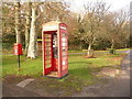
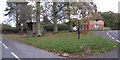
East Lulworth: postbox № BH20 72 and phone box
These two red objects stand on a triangular green on the junction of the road to Coombe Keynes. The postbox is emptied finally at 5:15pm on weekdays and at 9am on Saturdays, while the neighbouring phone box is currently without its door.
Edit (April 2013): the door has now been replaced - see Image
Image: © Chris Downer
Taken: 22 Nov 2009
0.16 miles
9
East Lulworth
This is where in the centre of the village, the minor road from Coombe Keynes meets the main road the B3070 from Lulworth to Wareham. The triangular green in the middle of the road junction accommodates all that a good country green should, including a red telephone box, a mail box, a bus stop and a bus shelter, a grit box, a sign post and some trees thrown in for good measure.
Image: © Nigel Mykura
Taken: 2 Feb 2013
0.16 miles
10
East Lulworth
East Lulworth from Coombe Keynes
Image: © Peter Elsdon
Taken: 1 Nov 2009
0.16 miles