IMAGES TAKEN NEAR TO
Coombe Keynes, WAREHAM, BH20 5PS
Introduction
This page details the photographs taken nearby to BH20 5PS by members of the Geograph project.
The Geograph project started in 2005 with the aim of publishing, organising and preserving representative images for every square kilometre of Great Britain, Ireland and the Isle of Man.

There are currently over 7.5m images from over14,400 individuals and you can help contribute to the project by visiting https://www.geograph.org.uk
Image Map (Loading...)


Getting Data...Please wait
Leaflet Map data © OpenStreetMap
Images are licensed for reuse under creativecommons.org/licenses/by-sa/2.0
Notes
- Clicking on the map will re-center to the selected point.
- The higher the marker number, the further away the image location is from the centre of the postcode.
Image Listing (29 Images Found)
Images are licensed for reuse under creativecommons.org/licenses/by-sa/2.0
Image
Details
Distance
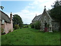
6
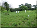
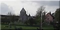
Dreamy days in Dorset 28: Coome Keynes
The Church of the Holy Rood has stood on this site for centuries and was renovated between 1860 and 1861.
Image: © Basher Eyre
Taken: 3 Sep 2012
0.01 miles
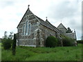
9
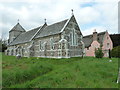
Coombe Keynes
View of the village Church
Image: © Peter Elsdon
Taken: 1 Nov 2009
0.03 miles
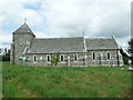
10
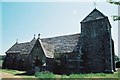
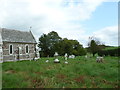
Coombe Keynes: parish church of the Holy Rood
Built in 1861 apart from the mediaeval tower.
Image: © Chris Downer
Taken: Unknown
0.03 miles