IMAGES TAKEN NEAR TO
Kingston, Corfe Castle, WAREHAM, BH20 5LP
Introduction
This page details the photographs taken nearby to BH20 5LP by members of the Geograph project.
The Geograph project started in 2005 with the aim of publishing, organising and preserving representative images for every square kilometre of Great Britain, Ireland and the Isle of Man.

There are currently over 7.5m images from over14,400 individuals and you can help contribute to the project by visiting https://www.geograph.org.uk
Image Map
Images are licensed for reuse under creativecommons.org/licenses/by-sa/2.0
Notes
- Clicking on the map will re-center to the selected point.
- The higher the marker number, the further away the image location is from the centre of the postcode.
Image Listing (6 Images Found)
Images are licensed for reuse under creativecommons.org/licenses/by-sa/2.0
Image
Details
Distance
1
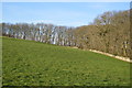
Orchard Hill Farm across a field
Livestock farm
Image: © N Chadwick
Taken: 11 Apr 2008
0.07 miles
2
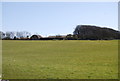
Dorset landscape
From this point on the road up to Swyre Head, the view towards Poole catches Corfe Castle right in the middle.
Image: © Val Pollard
Taken: 15 Jan 2012
0.14 miles
3
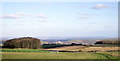
Stubble field with views
Looking across the field of stubble to distant views of Poole. Corfe Castle visible in the Purbeck gap.
Image: © Val Pollard
Taken: 15 Jan 2012
0.17 miles
4
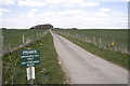
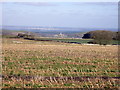
Track to Orchard Hill Farm, near Kimmeridge
On a clear day it is possible to see Poole Harbour in the centre of this view.
Image: © John Lamper
Taken: 10 Apr 2006
0.20 miles
5
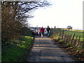
Here come the girls!
To be fair there is a lad too. A flock of sheep coming down a Dorset lane near to Kingston.
Image: © Val Pollard
Taken: 15 Jan 2012
0.23 miles