IMAGES TAKEN NEAR TO
Ower, WAREHAM, BH20 5JN
Introduction
This page details the photographs taken nearby to Ower, BH20 5JN by members of the Geograph project.
The Geograph project started in 2005 with the aim of publishing, organising and preserving representative images for every square kilometre of Great Britain, Ireland and the Isle of Man.

There are currently over 7.5m images from over14,400 individuals and you can help contribute to the project by visiting https://www.geograph.org.uk
Image Map (Loading...)


Getting Data...Please wait
Leaflet Map data © OpenStreetMap
Images are licensed for reuse under creativecommons.org/licenses/by-sa/2.0
Notes
- Clicking on the map will re-center to the selected point.
- The higher the marker number, the further away the image location is from the centre of the postcode.
Image Listing (17 Images Found)
Images are licensed for reuse under creativecommons.org/licenses/by-sa/2.0
Image
Details
Distance
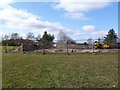
1
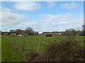
Ower Farm
At the southern end of the peninsula; judging from equipment, the business is equine.
Image: © Mike Faherty
Taken: 10 Mar 2012
0.03 miles
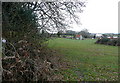
2

Barn at Ower Farm, Studland
Image: © Lorraine and Keith Bowdler
Taken: 1 Apr 2010
0.08 miles
3
Ower Farm
This farm is a long way from anywhere, except Poole Harbour. From Poole it must be quicker to reach it by boat than by road. The bridleway passes to the left.
Image: © Graham Horn
Taken: 13 Mar 2011
0.10 miles
4
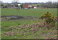
Ower Farm
This farm is a long way from anywhere, except Poole Harbour. From Poole it must be quicker to reach it by boat than by road. This is taken from the bridleway that runs to the north of the Newton Heath plantations, itself a lovely remote route.
Image: © Graham Horn
Taken: 13 Mar 2011
0.10 miles
5
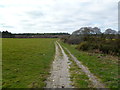
Ower, bridleway
Across farmland, from Goathorn to Rempstone Heath or Ower Quay.
Image: © Mike Faherty
Taken: 10 Mar 2012
0.13 miles
6
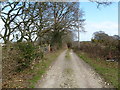
Ower, farm road
The drive to Ower Farm.
Image: © Mike Faherty
Taken: 10 Mar 2012
0.14 miles
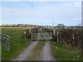
7
Ower, cattle grid
On the bridleway to Ower Quay. It seems that horses (and their riders) are expected to negotiate the narrow gap between lurching gate and grid, and step over barbed wire...
Image: © Mike Faherty
Taken: 10 Mar 2012
0.15 miles
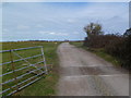
8
Ower, gate
On the bridleway to Ower Quay, across grazing land.
Image: © Mike Faherty
Taken: 10 Mar 2012
0.17 miles
9
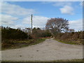
Ower, bridleway junction
Coming from Newton Heath: left, to Rempstone Heath; ahead, to Ower Quay; right, to Studland.
Image: © Mike Faherty
Taken: 10 Mar 2012
0.18 miles
10
Ower, excavation
Next to the bridleway to Ower Quay; what seems to be a pipeline under construction, presumably connecting with the neighbouring oil well. There is a similar pit to the East.
Image: © Mike Faherty
Taken: 10 Mar 2012
0.18 miles