IMAGES TAKEN NEAR TO
Holme Lane, WAREHAM, BH20 5DH
Introduction
This page details the photographs taken nearby to Holme Lane, BH20 5DH by members of the Geograph project.
The Geograph project started in 2005 with the aim of publishing, organising and preserving representative images for every square kilometre of Great Britain, Ireland and the Isle of Man.

There are currently over 7.5m images from over14,400 individuals and you can help contribute to the project by visiting https://www.geograph.org.uk
Image Map (Loading...)


Getting Data...Please wait
Leaflet Map data © OpenStreetMap
Images are licensed for reuse under creativecommons.org/licenses/by-sa/2.0
Notes
- Clicking on the map will re-center to the selected point.
- The higher the marker number, the further away the image location is from the centre of the postcode.
Image Listing (18 Images Found)
Images are licensed for reuse under creativecommons.org/licenses/by-sa/2.0
Image
Details
Distance
1
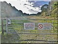
East Holme, warning signs
At the approach to East Holme Rifle Range, on the Lulworth Ranges. The butts are in the distance, out of sight.
Image: © Mike Faherty
Taken: 16 Nov 2017
0.00 miles
2
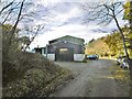
East Holme, motor engineers
Lovell & Barnes, at Doreys Farm.
Image: © Mike Faherty
Taken: 16 Nov 2017
0.05 miles
3
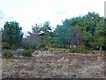
Edge of Holme Heath
MOD land to the right of the fence.
Image: © Jonathan Billinger
Taken: 10 Feb 2009
0.09 miles
4
East Holme, clay pit
Not possible to view the pit close-up, but it is an extensive site. It is operated by Imerys: http://www.imerys-ceramics.com/IndustrialSites.asp?I1_ID=1&I2_ID=&I3_ID=&IS_ZONE=2&IS_COUNTRY=10#map_country_details_82
Image: © Mike Faherty
Taken: 16 Nov 2017
0.10 miles
5
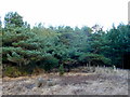
Edge of Holme Heath 2
To the south-west of Dorey's Farm.
Image: © Jonathan Billinger
Taken: 10 Feb 2009
0.10 miles
6

Clay Pit near Dorey's Farm
Clay has been extracted in this area for hundreds of years. Extensive Roman era kilns have recently been uncovered near Swineham Point and Josiah Wedgwood apparently sourced his clay from this area as well. Clay extraction continues now with modern methods. Note the colours of the exposed strata and the patterns made by the scoops.
Image: © David Squire
Taken: 29 Jan 2006
0.11 miles
7
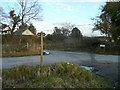
Bridleway sign at Dorey's Farm
The right-of-way appears to have been re-routed to a more east-west alignment than given on mapping.
Image: © Jonathan Billinger
Taken: 10 Feb 2009
0.11 miles
8
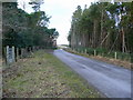
Farm road on Holme Heath
A public footpath has a gate to the left, but no corresponding stile over the wire to the right.
Image: © Jonathan Billinger
Taken: 10 Feb 2009
0.12 miles
9

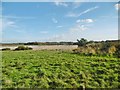
East Holme, Battle Plain
Wet grassland, where there is evidence of cattle grazing, despite the land's apparent poverty. Only a small portion of this OS square is accessible; most is on the MoD's Lulworth Ranges.
Image: © Mike Faherty
Taken: 16 Nov 2017
0.13 miles
