IMAGES TAKEN NEAR TO
Barnhill Road, WAREHAM, BH20 5BD
Introduction
This page details the photographs taken nearby to Barnhill Road, BH20 5BD by members of the Geograph project.
The Geograph project started in 2005 with the aim of publishing, organising and preserving representative images for every square kilometre of Great Britain, Ireland and the Isle of Man.

There are currently over 7.5m images from over14,400 individuals and you can help contribute to the project by visiting https://www.geograph.org.uk
Image Map
Images are licensed for reuse under creativecommons.org/licenses/by-sa/2.0
Notes
- Clicking on the map will re-center to the selected point.
- The higher the marker number, the further away the image location is from the centre of the postcode.
Image Listing (20 Images Found)
Images are licensed for reuse under creativecommons.org/licenses/by-sa/2.0
Image
Details
Distance
1
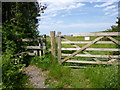
Ridge, gate & stile
At the beginning of the footpath to Nutcrack Lane.
Image: © Mike Faherty
Taken: 19 Jun 2013
0.06 miles
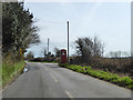
2
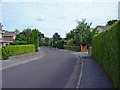
Ridge, crossroads
Left, New Road, to Stoborough Green; ahead, Nutcrack Lane, to Stoborough; right, Barnhill Road, to Ridge.
Image: © Mike Faherty
Taken: 19 Jun 2013
0.08 miles
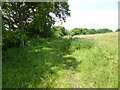
4
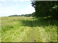
Ridge, footpath
Along a field margin, from Nutcrack Lane to Barnhill Road.
Image: © Mike Faherty
Taken: 19 Jun 2013
0.10 miles
5
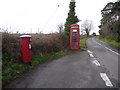
Phone box, Ridge
Also a bus stop and, behind the phone box, a post box.
Image: © Robin Webster
Taken: 1 Apr 2018
0.10 miles
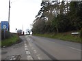
7
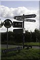
Ridge: postbox № BH20 177 and phone box
These two red objects serve the village of Ridge and are in a small layby by the crossroads. The postbox is emptied finally at 5:15pm on weekdays and at 10:15am Saturdays.
Image: © Chris Downer
Taken: 17 Jan 2009
0.12 miles
8
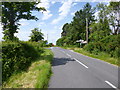
Ridge, footpath
Along a field margin, from Barnhill Road to Nutcrack Lane.
Image: © Mike Faherty
Taken: 19 Jun 2013
0.15 miles
9
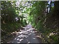
Ridge, private road
From the village centre to Redcliffe Farm, moorings and yacht club; the road also includes Purbeck Way path.
Image: © Mike Faherty
Taken: 19 Jun 2013
0.16 miles