IMAGES TAKEN NEAR TO
North Walls, WAREHAM, BH20 4QL
Introduction
This page details the photographs taken nearby to North Walls, BH20 4QL by members of the Geograph project.
The Geograph project started in 2005 with the aim of publishing, organising and preserving representative images for every square kilometre of Great Britain, Ireland and the Isle of Man.

There are currently over 7.5m images from over14,400 individuals and you can help contribute to the project by visiting https://www.geograph.org.uk
Image Map (Loading...)


Getting Data...Please wait
Leaflet Map data © OpenStreetMap
Images are licensed for reuse under creativecommons.org/licenses/by-sa/2.0
Notes
- Clicking on the map will re-center to the selected point.
- The higher the marker number, the further away the image location is from the centre of the postcode.
Image Listing (256 Images Found)
Images are licensed for reuse under creativecommons.org/licenses/by-sa/2.0
Image
Details
Distance
1
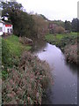
R. Piddle from the North bridge, Wareham
Image: © N Chadwick
Taken: 26 Oct 2006
0.02 miles
2
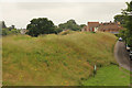
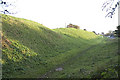
Wareham Walls
Northern town walls at Wareham
Image: © Richard Croft
Taken: 10 Jul 2016
0.03 miles
3
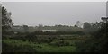
Wareham
Looking across Worgret Heath towards Wareham town behind 'The Walls'. The town bypass (A351) to the foreground.
Image: © Peter Elsdon
Taken: 9 Nov 2009
0.03 miles
4
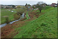
River Piddle at Wareham
Flowing away from the camera beneath the north walls https://historicengland.org.uk/listing/the-list/list-entry/1003574 . To the right of the river is the leat feeding the North Mill.
Image: © Derek Harper
Taken: 4 Apr 2019
0.04 miles
5
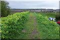
Town walls, Wareham
Footpath SE2 13 runs between alexanders along the top of the rampart https://historicengland.org.uk/listing/the-list/list-entry/1003574 towards the Piddle valley. On the other side is Northport.
Image: © Derek Harper
Taken: 4 Apr 2019
0.04 miles
6
The north wall of Wareham
Seen from the north-west corner
Image: © David Smith
Taken: 24 Jan 2018
0.05 miles
7
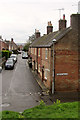
Roper's Lane, Wareham
The terrace of four is listed https://historicengland.org.uk/listing/the-list/list-entry/1119960 : "C18. Pink brick with vitrified headers". View from the town walls.
Image: © Derek Harper
Taken: 4 Apr 2019
0.05 miles
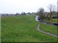
8

Wareham, Piddle valley
Looking down into the valley from the north-western corner of the town walls, with water meadows and North Bridge in the distance.
Image: © Mike Faherty
Taken: 24 Jul 2010
0.05 miles
9
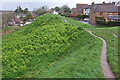
Town walls, Wareham
Footpath SE2 13 progresses along the northern section of the ramparts https://historicengland.org.uk/listing/the-list/list-entry/1003574 . Below left is the North Mill https://historicengland.org.uk/listing/the-list/list-entry/1153198 .
Image: © Derek Harper
Taken: 4 Apr 2019
0.05 miles
10
Saxon Walls, Wareham, Dorset
Wareham’s Saxon walls are ancient earth ramparts surrounding the town. The walls were built by Alfred the Great in the 9th century to defend the town from Norsemen.
Image: © John Lamper
Taken: 19 Nov 2005
0.06 miles