IMAGES TAKEN NEAR TO
Bestwall Crescent, WAREHAM, BH20 4JB
Introduction
This page details the photographs taken nearby to Bestwall Crescent, BH20 4JB by members of the Geograph project.
The Geograph project started in 2005 with the aim of publishing, organising and preserving representative images for every square kilometre of Great Britain, Ireland and the Isle of Man.

There are currently over 7.5m images from over14,400 individuals and you can help contribute to the project by visiting https://www.geograph.org.uk
Image Map (Loading...)


Getting Data...Please wait
Leaflet Map data © OpenStreetMap
Images are licensed for reuse under creativecommons.org/licenses/by-sa/2.0
Notes
- Clicking on the map will re-center to the selected point.
- The higher the marker number, the further away the image location is from the centre of the postcode.
Image Listing (38 Images Found)
Images are licensed for reuse under creativecommons.org/licenses/by-sa/2.0
Image
Details
Distance
1
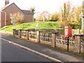
Wareham: postbox № BH20 214, Bestwall Road
This little postbox serves the eastern parts of the town and is emptied finally at 5:30pm on weekdays and at 12:15pm on Saturdays. Behind it, we see the grassy remains of the old town walls which survive around most of the northern half of the town's perimeter.
Image: © Chris Downer
Taken: 22 Nov 2009
0.12 miles
2
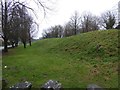
Town walls, east, Wareham
Part of the Anglo-Saxon walls surrounding the town.
Image: © N Chadwick
Taken: 8 Apr 2008
0.12 miles
3
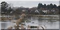
Bestwall Nature Reserve - Wareham
Looking across Bestwall Nature Reserve towards Bestwall Road Wareham. The Reserve is a site Of Special Scientific Interest because of the wildfowl and wading birds. High water levels are maintained in the ditches and some fields are flooded in the winter to provide ideal conditions.
Image: © Peter Elsdon
Taken: 1 Mar 2010
0.12 miles
4
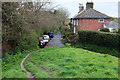
East Walls, Wareham
The nearest house can be seen ahead in Image The two, with chequer brick, are listed https://historicengland.org.uk/listing/the-list/list-entry/1152612 . Footpath SE2 18 drops from the town walls https://historicengland.org.uk/listing/the-list/list-entry/1003574 .
Image: © Derek Harper
Taken: 4 Apr 2019
0.13 miles
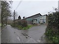
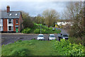
5
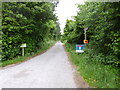
Wareham, Bestwall Road
A private road with right of way, leading from East Street to the Bestwall Estate.
Image: © Mike Faherty
Taken: 16 Jun 2013
0.13 miles
6
Wareham Town Walls
From close to where it is crossed by East Street, as shown in Image The footpath is SE2 14#2. https://historicengland.org.uk/listing/the-list/list-entry/1003574 . The house ahead is also seen in Image] and is listed https://historicengland.org.uk/listing/the-list/list-entry/1003574 .
Image: © Derek Harper
Taken: 4 Apr 2019
0.14 miles
7
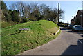
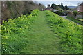
Town Walls and East Street, Wareham
The walk around the grassy ramparts drops to cross East Street. https://historicengland.org.uk/listing/the-list/list-entry/1003574
Image: © Derek Harper
Taken: 4 Apr 2019
0.15 miles
8
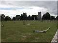
Wareham, cemetery
One of three graveyards on Conniger Lane; Lady St. Mary's Church in the background.
Image: © Mike Faherty
Taken: 24 Jul 2010
0.15 miles