IMAGES TAKEN NEAR TO
Westerman Way, WAREHAM, BH20 4FL
Introduction
This page details the photographs taken nearby to Westerman Way, BH20 4FL by members of the Geograph project.
The Geograph project started in 2005 with the aim of publishing, organising and preserving representative images for every square kilometre of Great Britain, Ireland and the Isle of Man.

There are currently over 7.5m images from over14,400 individuals and you can help contribute to the project by visiting https://www.geograph.org.uk
Image Map (Loading...)


Getting Data...Please wait
Leaflet Map data © OpenStreetMap
Images are licensed for reuse under creativecommons.org/licenses/by-sa/2.0
Notes
- Clicking on the map will re-center to the selected point.
- The higher the marker number, the further away the image location is from the centre of the postcode.
Image Listing (37 Images Found)
Images are licensed for reuse under creativecommons.org/licenses/by-sa/2.0
Image
Details
Distance
3

Wareham, mill stream
Draining into the nearby River Piddle; rich in plantlife, but infested with Australian swamp stonecrop.
Image: © Mike Faherty
Taken: 24 Jul 2010
0.13 miles
6
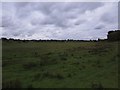
Wareham Common
Compare its current lushness after recent heavy rain with its parched condition five weeks ago after prolonged drought Image
Image: © Mike Faherty
Taken: 9 Sep 2010
0.15 miles
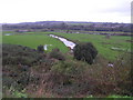
7
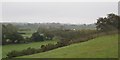
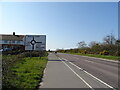
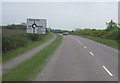
Wareham - Worgret Heath
Wareham bypass (A351) The blue building by the tree to the right is 'Auto Point' garage in North Street Wareham
Image: © Peter Elsdon
Taken: 9 Nov 2009
0.15 miles
8
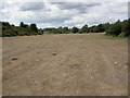
Wareham Common
Flat and parched after a dry summer; very different from the nearby water meadows, which are also common land Image For its legal status, see http://www.precisionproductions.com/courtleet/cl_resources/Wareham%20Common%20and%20Town%20Walls.pdf
Image: © Mike Faherty
Taken: 2 Aug 2010
0.15 miles
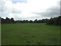
9
The River Piddle & flood plain, West of Wareham
One of the 2 rivers flowing through Wareham
Image: © N Chadwick
Taken: 26 Oct 2006
0.16 miles