IMAGES TAKEN NEAR TO
Worth Matravers, SWANAGE, BH19 3LL
Introduction
This page details the photographs taken nearby to BH19 3LL by members of the Geograph project.
The Geograph project started in 2005 with the aim of publishing, organising and preserving representative images for every square kilometre of Great Britain, Ireland and the Isle of Man.

There are currently over 7.5m images from over14,400 individuals and you can help contribute to the project by visiting https://www.geograph.org.uk
Image Map (Loading...)


Getting Data...Please wait
Leaflet Map data © OpenStreetMap
Images are licensed for reuse under creativecommons.org/licenses/by-sa/2.0
Notes
- Clicking on the map will re-center to the selected point.
- The higher the marker number, the further away the image location is from the centre of the postcode.
Image Listing (61 Images Found)
Images are licensed for reuse under creativecommons.org/licenses/by-sa/2.0
Image
Details
Distance
1

Converted barn at Renscombe Farm, Worth Matravers, Isle of Purbeck
Image: © Phil Champion
Taken: 7 Sep 2017
0.00 miles
2

Modern Milestone by Renscombe Road, Worth Matravers parish
Stone post by the UC road, in parish of Worth Matravers (Purbeck District), Renscombe Road, Renscombe Farm, 50m East of farmhouse on top of stone wall.
Inscription reads:-
ST ALDHELMS
QUARRY {<-arrow}
W. J. HAYSOM & SON
One Mile
Surveyed
Milestone Society National ID: DO_XWOM
Image: © Milestone Society
Taken: Unknown
0.02 miles
3
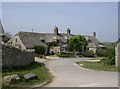
Renscombe, stone cottages
Next to Renscombe Farm, which appears no longer to be a working farm.
Image: © Mike Faherty
Taken: 24 Apr 2011
0.02 miles
5
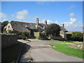
Renscombe Farm
Looks like a farm conversion for holiday cottages.
Image: © Les Hull
Taken: 27 Aug 2015
0.03 miles
7
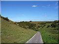
ORPA from Renscombe Farm
The route down to Hill Bottom, and continuing towards Kingston is shown on OS maps as an ORPA, suggesting it is included on the highway authorities 'List of Streets'. This part at least has a sealed surface.
Image: © Phil Champion
Taken: 25 Sep 2009
0.05 miles
8
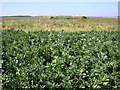
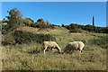
Bean crop and wild grasses on West Hill, Worth Matravers, Isle of Purbeck
View north of the footpath from car park to Chapman's Pool, with a bean crop in the foreground, wild grasses and flowers beyond that and Kingston Down in the distance. The steep-sided coombe that makes up the NW half of this grid square is hidden from this viewpoint.
Image: © Jim Champion
Taken: 16 Jul 2005
0.06 miles
9
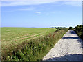
Field and track to St Aldhelm's Head from Renscombe Farm, Isle of Purbeck
Looking south along the track that leads from Renscombe Farm, west of Worth Matravers, to the chapel, coastguard and cottages at St Aldhelm's Head. This is the most direct walking route to the headland from the public car park south of Renscombe Farm - easier but not as dramatic as the walk along the coastal footpath over Emmetts Hill.
Image: © Jim Champion
Taken: 16 Jul 2005
0.06 miles
10
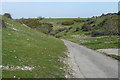
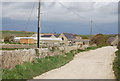
Track from Renscombe Farm
The track leads through the farm and into Renscombe itself, where there are a few houses. It offers a more gentle route to Chapman's Pool than the footpaths.
Image: © Graham Horn
Taken: 12 Mar 2011
0.07 miles