IMAGES TAKEN NEAR TO
Manwell Drive, SWANAGE, BH19 2RB
Introduction
This page details the photographs taken nearby to Manwell Drive, BH19 2RB by members of the Geograph project.
The Geograph project started in 2005 with the aim of publishing, organising and preserving representative images for every square kilometre of Great Britain, Ireland and the Isle of Man.

There are currently over 7.5m images from over14,400 individuals and you can help contribute to the project by visiting https://www.geograph.org.uk
Image Map (Loading...)


Getting Data...Please wait
Leaflet Map data © OpenStreetMap
Images are licensed for reuse under creativecommons.org/licenses/by-sa/2.0
Notes
- Clicking on the map will re-center to the selected point.
- The higher the marker number, the further away the image location is from the centre of the postcode.
Image Listing (205 Images Found)
Images are licensed for reuse under creativecommons.org/licenses/by-sa/2.0
Image
Details
Distance
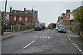
1
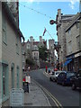
Swanage - High Street
Westward view see the virtual Swanage website to compare with a late 1800's web site.
Image: © Steve Cook
Taken: 19 Aug 2005
0.01 miles
4
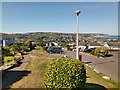
Hoburne Park estate, Swanage,
Some excellent sea views are enjoyed by the residents of the immaculate park homes sited at this well kept estate on the hillside above Swanage.
Image: © Tim Marshall
Taken: 25 Jun 2020
0.06 miles
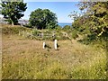
5
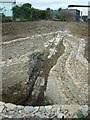
Reconstructed quarr at Hoburne Park, Swanage
The picture shows a quarr shortly after its reconstruction in 2002.
For hundreds of years until the 1960s most quarrying of Purbeck stone was done from workings called 'Quarrs'. Stone quarried underground was hauled to the surface on a trundle (a small cart), pulled up an incline, known as the slide, by a horse or donkey working a capstan. The whole complex would have been surrounded by a boundary wall, and many quarrs had ancillary buildings, such as a stable.
This quarr fell into disuse, and a park home site was developed around it. In 2002 several of these quarrs in the area were restored, both for their industrial archaeological interest, and as habitat for bats, including some very rare species.
The picture shows the restored slide and retaining walls of this quarr, the entrance to the underground workings being immediately below the photographer. The capstan and other structures have not been restored.
Image: © Caroline Tandy
Taken: 4 Oct 2002
0.09 miles
7
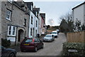
Swanage, stone cottages
On Cowlease, off High Street.
Image: © Mike Faherty
Taken: 21 Mar 2012
0.10 miles
10
Former mine workings, Townsend Nature Reserve
I believe this to be a former pit shaft associated with the stone quarrying activities of the area.
Image: © Tim Marshall
Taken: 25 Jun 2020
0.11 miles