IMAGES TAKEN NEAR TO
Hillsea Road, SWANAGE, BH19 2QN
Introduction
This page details the photographs taken nearby to Hillsea Road, BH19 2QN by members of the Geograph project.
The Geograph project started in 2005 with the aim of publishing, organising and preserving representative images for every square kilometre of Great Britain, Ireland and the Isle of Man.

There are currently over 7.5m images from over14,400 individuals and you can help contribute to the project by visiting https://www.geograph.org.uk
Image Map (Loading...)


Getting Data...Please wait
Leaflet Map data © OpenStreetMap
Images are licensed for reuse under creativecommons.org/licenses/by-sa/2.0
Notes
- Clicking on the map will re-center to the selected point.
- The higher the marker number, the further away the image location is from the centre of the postcode.
Image Listing (66 Images Found)
Images are licensed for reuse under creativecommons.org/licenses/by-sa/2.0
Image
Details
Distance
8
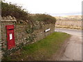
Herston: postbox № BH19 216, Hill View Road
This George VI-reign postbox is emptied finally at 4pm on weekdays and at noon on Saturdays. Beyond it, we get an idea of how Hill View Road got its name.
Image: © Chris Downer
Taken: 20 Feb 2010
0.08 miles