IMAGES TAKEN NEAR TO
Manwell Road, SWANAGE, BH19 2QD
Introduction
This page details the photographs taken nearby to Manwell Road, BH19 2QD by members of the Geograph project.
The Geograph project started in 2005 with the aim of publishing, organising and preserving representative images for every square kilometre of Great Britain, Ireland and the Isle of Man.

There are currently over 7.5m images from over14,400 individuals and you can help contribute to the project by visiting https://www.geograph.org.uk
Image Map (Loading...)


Getting Data...Please wait
Leaflet Map data © OpenStreetMap
Images are licensed for reuse under creativecommons.org/licenses/by-sa/2.0
Notes
- Clicking on the map will re-center to the selected point.
- The higher the marker number, the further away the image location is from the centre of the postcode.
Image Listing (213 Images Found)
Images are licensed for reuse under creativecommons.org/licenses/by-sa/2.0
Image
Details
Distance
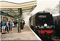
1
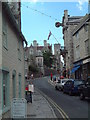
Swanage - High Street
Westward view see the virtual Swanage website to compare with a late 1800's web site.
Image: © Steve Cook
Taken: 19 Aug 2005
0.03 miles
6
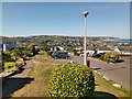
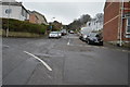
Hoburne Park estate, Swanage,
Some excellent sea views are enjoyed by the residents of the immaculate park homes sited at this well kept estate on the hillside above Swanage.
Image: © Tim Marshall
Taken: 25 Jun 2020
0.09 miles
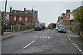
8
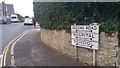
Signpost / street name plate at Queens Road, Swanage
With arrows pointing to Queens Road, Hospital and School.
Image: © Phil Champion
Taken: 12 Sep 2018
0.09 miles