IMAGES TAKEN NEAR TO
High Street, SWANAGE, BH19 2PF
Introduction
This page details the photographs taken nearby to High Street, BH19 2PF by members of the Geograph project.
The Geograph project started in 2005 with the aim of publishing, organising and preserving representative images for every square kilometre of Great Britain, Ireland and the Isle of Man.

There are currently over 7.5m images from over14,400 individuals and you can help contribute to the project by visiting https://www.geograph.org.uk
Image Map (Loading...)


Getting Data...Please wait
Leaflet Map data © OpenStreetMap
Images are licensed for reuse under creativecommons.org/licenses/by-sa/2.0
Notes
- Clicking on the map will re-center to the selected point.
- The higher the marker number, the further away the image location is from the centre of the postcode.
Image Listing (79 Images Found)
Images are licensed for reuse under creativecommons.org/licenses/by-sa/2.0
Image
Details
Distance
2

Swanage, dovecote
On the gable end of what was originally an outhouse of Newton Manor, on High Street.
Image: © Mike Faherty
Taken: 21 Mar 2012
0.03 miles
6
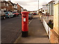
Swanage: postbox № BH19 33, Kings Road West
This George V-reign postbox is emptied finally at 5:15pm on weekdays and at noon on Saturdays.
Image: © Chris Downer
Taken: 20 Feb 2010
0.08 miles