IMAGES TAKEN NEAR TO
High Street, SWANAGE, BH19 2NT
Introduction
This page details the photographs taken nearby to High Street, BH19 2NT by members of the Geograph project.
The Geograph project started in 2005 with the aim of publishing, organising and preserving representative images for every square kilometre of Great Britain, Ireland and the Isle of Man.

There are currently over 7.5m images from over14,400 individuals and you can help contribute to the project by visiting https://www.geograph.org.uk
Image Map (Loading...)


Getting Data...Please wait
Leaflet Map data © OpenStreetMap
Images are licensed for reuse under creativecommons.org/licenses/by-sa/2.0
Notes
- Clicking on the map will re-center to the selected point.
- The higher the marker number, the further away the image location is from the centre of the postcode.
Image Listing (708 Images Found)
Images are licensed for reuse under creativecommons.org/licenses/by-sa/2.0
Image
Details
Distance
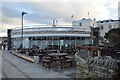
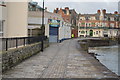
2
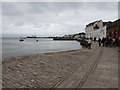
Coast path, Swanage
Passing the former market building on the seafront.
Image: © Derek Harper
Taken: 4 Apr 2019
0.01 miles
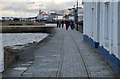
5
Tramlines at Swanage
A tramway once carried stone to the pier at Swanage. It has been closed for many years, but these tramlines are a reminder of its existence.
Image: © Malc McDonald
Taken: 17 Aug 2012
0.01 miles
6
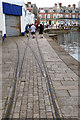
Tramway track turnout
The tracks mark the route of a tramway which ran along the quayside here. It was built in the late 1800s, initially to carry Purbeck stone for onward shipment. Later it was used to transport fish and the turnout shown here led into the fish market. The old market building is now an amusement arcade but is currently closed.
Image: © John Lucas
Taken: 22 Sep 2020
0.01 miles
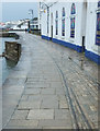
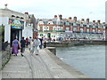
8
Swanage, former weighbridge
Inscriptions at the top of the stone courses read "Mr Charles Burts Stone Office. Weighbridge not to exceed 10 tons"; and at ground level, the tolls: stone 1d, coal 2d, hay & straw per load 6d. The Building is now Swanage Angling Centre.
Image: © Mike Faherty
Taken: 16 Mar 2009
0.01 miles
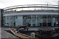
9
Swanage sea front, pier and tramway remains
More details of the tramway can be found at https://en.wikipedia.org/wiki/Swanage_Pier_Tramway
Image: © Nigel Thompson
Taken: 16 Jun 2018
0.01 miles