IMAGES TAKEN NEAR TO
High Street, SWANAGE, BH19 2NR
Introduction
This page details the photographs taken nearby to High Street, BH19 2NR by members of the Geograph project.
The Geograph project started in 2005 with the aim of publishing, organising and preserving representative images for every square kilometre of Great Britain, Ireland and the Isle of Man.

There are currently over 7.5m images from over14,400 individuals and you can help contribute to the project by visiting https://www.geograph.org.uk
Image Map
Images are licensed for reuse under creativecommons.org/licenses/by-sa/2.0
Notes
- Clicking on the map will re-center to the selected point.
- The higher the marker number, the further away the image location is from the centre of the postcode.
Image Listing (80 Images Found)
Images are licensed for reuse under creativecommons.org/licenses/by-sa/2.0
Image
Details
Distance
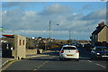
3
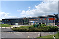
The Swanage School and bus shelter
Not just the best school in Dorset (according to the banner) but it has a very good wall to walk along!
Image: © David Smith
Taken: 30 Mar 2017
0.02 miles
4
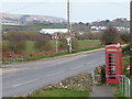
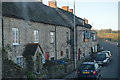
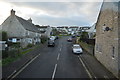
Herston: phone box on the A351
A red phone box stands just east of the Day's Road turning - misplaced on the map as being to the west of the junction.
Image: © Chris Downer
Taken: 2 Mar 2013
0.03 miles
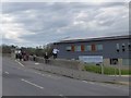
7
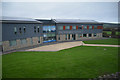
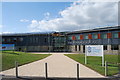
Swanage : The Swanage School
The Swanage School seen from the High Street.
Image: © Lewis Clarke
Taken: 28 Oct 2017
0.04 miles