IMAGES TAKEN NEAR TO
High Street, SWANAGE, BH19 2LT
Introduction
This page details the photographs taken nearby to High Street, BH19 2LT by members of the Geograph project.
The Geograph project started in 2005 with the aim of publishing, organising and preserving representative images for every square kilometre of Great Britain, Ireland and the Isle of Man.

There are currently over 7.5m images from over14,400 individuals and you can help contribute to the project by visiting https://www.geograph.org.uk
Image Map (Loading...)


Getting Data...Please wait
Leaflet Map data © OpenStreetMap
Images are licensed for reuse under creativecommons.org/licenses/by-sa/2.0
Notes
- Clicking on the map will re-center to the selected point.
- The higher the marker number, the further away the image location is from the centre of the postcode.
Image Listing (971 Images Found)
Images are licensed for reuse under creativecommons.org/licenses/by-sa/2.0
Image
Details
Distance

5
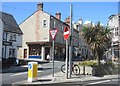
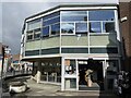
High Street, Swanage
The junction with Kings Road East (left). The two K6 telephone boxes are listed https://historicengland.org.uk/listing/the-list/list-entry/1390872 . Behind them is the Anchor Inn https://historicengland.org.uk/listing/the-list/list-entry/1323620 . On the immediate left is The Arcade https://historicengland.org.uk/listing/the-list/list-entry/1152394 .
Image: © Derek Harper
Taken: 4 Apr 2019
0.01 miles
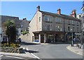
6
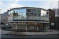
Swanage Library
The octagonal town library is a splendidly dinky example of 1960s civic bravado.
Image: © Mike Parker
Taken: 18 Mar 2023
0.01 miles
7
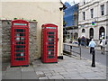
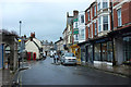
Swanage: phone boxes outside the library
Two traditional red phone boxes stand outside Image
Image: © Chris Downer
Taken: 2 Mar 2013
0.01 miles
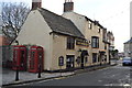
10
![Swanage buildings [8]](https://s1.geograph.org.uk/geophotos/06/78/55/6785557_794ab5a1_120x120.jpg)
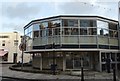
Swanage buildings [8]
The Anchor Inn, number 28 High Street, is in three part. A central three-storey section and two side two-storey sections which are former houses incorporated into the inn. The inn is probably 17th century in origin and has been much altered. Listed, grade II, with details at: https://historicengland.org.uk/listing/the-list/list-entry/1323620
Swanage is a coastal town in the Isle of Purbeck, some 6 miles south of Poole and 25 miles east of Dorchester. Originally a small port and fishing village the town flourished in the Victorian era after the arrival of the railway and it first became a significant quarrying port and later a seaside resort. Tourism is an important part of the economy albeit seasonal and residents commute to Poole and Bournemouth for permanent employment. The town is the terminus of the heritage Swanage Railway.
Image: © Michael Dibb
Taken: 12 Dec 2020
0.01 miles