IMAGES TAKEN NEAR TO
Higher Days Road, SWANAGE, BH19 2LB
Introduction
This page details the photographs taken nearby to Higher Days Road, BH19 2LB by members of the Geograph project.
The Geograph project started in 2005 with the aim of publishing, organising and preserving representative images for every square kilometre of Great Britain, Ireland and the Isle of Man.

There are currently over 7.5m images from over14,400 individuals and you can help contribute to the project by visiting https://www.geograph.org.uk
Image Map (Loading...)


Getting Data...Please wait
Leaflet Map data © OpenStreetMap
Images are licensed for reuse under creativecommons.org/licenses/by-sa/2.0
Notes
- Clicking on the map will re-center to the selected point.
- The higher the marker number, the further away the image location is from the centre of the postcode.
Image Listing (40 Images Found)
Images are licensed for reuse under creativecommons.org/licenses/by-sa/2.0
Image
Details
Distance
3
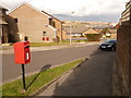
Herston: postbox № BH19 228, Higher Day?s Road
A small postbox serving a fairly modern estate, emptied finally at 4pm on weekdays and at noon on Saturdays. Ballard Down can be seen in the distance.
Image: © Chris Downer
Taken: 20 Feb 2010
0.08 miles
7
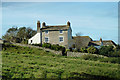
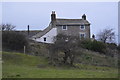
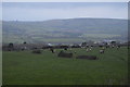
Belle Vue Farm
The house certainly has une belle vue, and it's not bad itself.
Image: © Robin Webster
Taken: 30 Oct 2012
0.14 miles