IMAGES TAKEN NEAR TO
Solent Road, SWANAGE, BH19 2HW
Introduction
This page details the photographs taken nearby to Solent Road, BH19 2HW by members of the Geograph project.
The Geograph project started in 2005 with the aim of publishing, organising and preserving representative images for every square kilometre of Great Britain, Ireland and the Isle of Man.

There are currently over 7.5m images from over14,400 individuals and you can help contribute to the project by visiting https://www.geograph.org.uk
Image Map
Images are licensed for reuse under creativecommons.org/licenses/by-sa/2.0
Notes
- Clicking on the map will re-center to the selected point.
- The higher the marker number, the further away the image location is from the centre of the postcode.
Image Listing (45 Images Found)
Images are licensed for reuse under creativecommons.org/licenses/by-sa/2.0
Image
Details
Distance
1
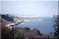
Durlston Bay from Durlston Castle
Looking almost directly northwards.
Image: © John Lucas
Taken: 14 Apr 1968
0.04 miles
2
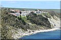
View Towards Peveril Point from Durlston
Taken from the path down into Swanage from the Country Park
Image: © Nigel Mykura
Taken: 10 May 2008
0.05 miles
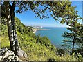
5

Durlston Bay from viewpoint near Durlston Head
Beyond Peveril Point lies Swanage Bay and Ballard Cliffs.
Image: © Phil Champion
Taken: 12 Sep 2018
0.12 miles
6
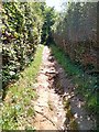
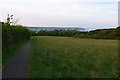
Pathway leading to Durlston Country Park, Swanage
Public footpath looking towards Durlston
Image: © Tim Marshall
Taken: 25 Jun 2020
0.12 miles
7
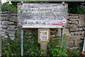
Private property notice at Durlston Country Park
Dating from 1878, when George Burt was developing the Durlston estate as a tourist attraction. This is now beside a public footpath entering woodland in Durlston Country Park.
Image: © Phil Champion
Taken: 22 Sep 2009
0.12 miles
8
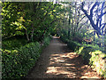
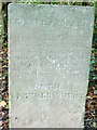
Old footpath sign
Difficult to read because of faded paint. This path does not appear on the 1:50000 but does on the 1:25000. Situated just off the road from Swanage to Durlston Country Park there is another similar sign a few hundred metres away at the end of this small straight section of path.
Image: © Nigel Mykura
Taken: 10 May 2008
0.12 miles
9
View over Durlston Bay
From a path in Durlston Country Park. The nearer headland in the photo is Peveril Point and the further is Handfast Point
Image: © Graham Hogg
Taken: 6 Aug 2022
0.13 miles
10
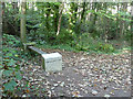
Literary bench at Durlston Country Park
Durlston is home a quite a number of Victorian inscribed stone objects, including the famous globe, and several benches inscribed with the names of playwrights and poets. Many have been refurbished as part of 'the Durlston Project' although for some reason on one of the bench ends has been cleaned. http://www.durlston.co.uk/index.php?id=57
Image: © Phil Champion
Taken: 22 Sep 2009
0.13 miles