IMAGES TAKEN NEAR TO
Seymer Road, SWANAGE, BH19 2FG
Introduction
This page details the photographs taken nearby to Seymer Road, BH19 2FG by members of the Geograph project.
The Geograph project started in 2005 with the aim of publishing, organising and preserving representative images for every square kilometre of Great Britain, Ireland and the Isle of Man.

There are currently over 7.5m images from over14,400 individuals and you can help contribute to the project by visiting https://www.geograph.org.uk
Image Map (Loading...)


Getting Data...Please wait
Leaflet Map data © OpenStreetMap
Images are licensed for reuse under creativecommons.org/licenses/by-sa/2.0
Notes
- Clicking on the map will re-center to the selected point.
- The higher the marker number, the further away the image location is from the centre of the postcode.
Image Listing (604 Images Found)
Images are licensed for reuse under creativecommons.org/licenses/by-sa/2.0
Image
Details
Distance
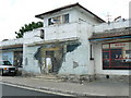
1
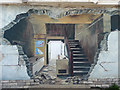
A Broken House, Swanage, Dorset
In fact it's not. This is a mural/graffiti.
Image: © Christine Matthews
Taken: 26 Apr 2012
0.00 miles
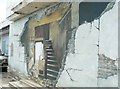
2
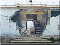
Broken House, Swanage, Dorset
I took this second image to illustrate the mural/graffiti. In fact by including the steps makes this look more rather than less realistic.
Image: © Christine Matthews
Taken: 26 Apr 2012
0.00 miles
3
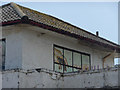
Graffiti/Mural, Swanage, Dorset
I'm not quite tall enough to fully photograph this mural on the same building as the broken house.
Image: © Christine Matthews
Taken: 26 Apr 2012
0.00 miles
4
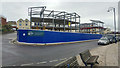
Redevelopment of the Pier Head site, High Street, Swanage
This was previously the site of the Pier Head building, built as a temporary mess hall in the 1940s. It was later used as a windsurfing school, cafe and bingo hall. The building had been empty and decaying since the 1990s.
In 2007 the building was decorated with trompe l'oeil murals depicting the past, present and possible future of the building.
Plans for redevelopment of the site were approved in 2017 and 2018. The new building will house apartments and retail units.
Image: © Phil Champion
Taken: 12 Sep 2018
0.00 miles
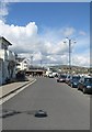
5
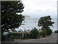
Swanage Bay
In the foreground, left, is the local gig rowing club's boathouse. The headland in the distance is The Foreland or Handfast Point ( SZ0582 ).
Image: © E Gammie
Taken: 10 Sep 2012
0.00 miles
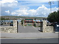
6
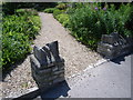
Prince Albert Gardens entrance
Image: © Nick Mutton 01329 000000
Taken: 22 Jun 2008
0.01 miles