IMAGES TAKEN NEAR TO
Queens Road, SWANAGE, BH19 2EU
Introduction
This page details the photographs taken nearby to Queens Road, BH19 2EU by members of the Geograph project.
The Geograph project started in 2005 with the aim of publishing, organising and preserving representative images for every square kilometre of Great Britain, Ireland and the Isle of Man.

There are currently over 7.5m images from over14,400 individuals and you can help contribute to the project by visiting https://www.geograph.org.uk
Image Map (Loading...)


Getting Data...Please wait
Leaflet Map data © OpenStreetMap
Images are licensed for reuse under creativecommons.org/licenses/by-sa/2.0
Notes
- Clicking on the map will re-center to the selected point.
- The higher the marker number, the further away the image location is from the centre of the postcode.
Image Listing (284 Images Found)
Images are licensed for reuse under creativecommons.org/licenses/by-sa/2.0
Image
Details
Distance
2
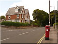
Swanage: postbox № BH19 122, Queen?s Road
During the period 1879-1887, an oversight meant that the Victorian cipher was omitted from the front of postboxes, giving them the nickname 'anonymous' boxes. Here we see an example of such a box, also notable for its slot being in a higher position than normal.
This box is on the top section of Queen's Road and is emptied finally at 5:30pm on weekdays and at noon on Saturdays.
Image: © Chris Downer
Taken: 21 Jun 2009
0.04 miles
3
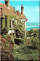
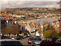
Swanage Youth Hostel
View from the back garden
Image: © norman griffin
Taken: 16 May 1959
0.07 miles
4
Swanage: postbox № BH19 123, Park Road
This Edward VII-reign postbox is emptied finally at 4pm on weekdays and at noon on Saturdays.
Image: © Chris Downer
Taken: 20 Feb 2010
0.09 miles
7
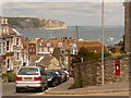
Swanage: postbox № BH19 35, Manor Road
A Victorian postbox set into a wall on the corner of Manor (right) and Stafford (ahead) Roads. It is emptied finally at 5:30pm on weekdays and at noon on Saturdays.
The view beyond is similar to Image
Image: © Chris Downer
Taken: 21 Jun 2009
0.13 miles
8
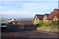
Swanage: townward view along Park Road
Park Road descends steeply towards the town centre, giving us this super view across the bay, with the backdrop of Ballard Down.
Image: © Chris Downer
Taken: 20 Feb 2010
0.13 miles
9
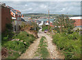
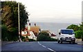
Sentry Road, Swanage
This unsurfaced lane runs steeply down towards the sea. This picture was taken after a night of very heavy rain and a good portion of the track surface was now down in the street below.
Image: © Des Blenkinsopp
Taken: 11 Sep 2011
0.13 miles
10
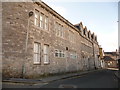
Swanage: former Masonic Hall, Marshall Row
Writing above the door shows that this building has been a Masonic Hall and also offices of the Gas and Water company – see Image
Image: © Chris Downer
Taken: 20 Feb 2010
0.16 miles