IMAGES TAKEN NEAR TO
Queens Road, SWANAGE, BH19 2ES
Introduction
This page details the photographs taken nearby to Queens Road, BH19 2ES by members of the Geograph project.
The Geograph project started in 2005 with the aim of publishing, organising and preserving representative images for every square kilometre of Great Britain, Ireland and the Isle of Man.

There are currently over 7.5m images from over14,400 individuals and you can help contribute to the project by visiting https://www.geograph.org.uk
Image Map (Loading...)


Getting Data...Please wait
Leaflet Map data © OpenStreetMap
Images are licensed for reuse under creativecommons.org/licenses/by-sa/2.0
Notes
- Clicking on the map will re-center to the selected point.
- The higher the marker number, the further away the image location is from the centre of the postcode.
Image Listing (243 Images Found)
Images are licensed for reuse under creativecommons.org/licenses/by-sa/2.0
Image
Details
Distance
1
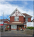
Swanage Cottage Hospital
Swanage Cottage Hospital, with the name in tiles over the door, dates from 1890.
It became an NHS hospital in 1948 and is still open.
If not a cottage, it certainly looks more like somebody's house than a medical facility.
A point in time detail, the flag in front is at half mast to mark the recent death of Queen Elizabeth.
Image: © Des Blenkinsopp
Taken: 12 Sep 2022
0.01 miles
2
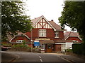
Swanage: the hospital
The hospital stands on the corner of Queen's Road (right and behind) and Bon Accord Road (left), and has ornate tile-work depicting the words 'Swanage Cottage Hospital' above the front entrance.
Image: © Chris Downer
Taken: 21 Jun 2009
0.01 miles
3
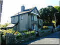
'Sunset' 53 Queens Road Durlston
This house was built in 1934 by Thomas Masters Hardy for himself, his wife Hester and three children, Joan, Llewellyn and Ronald. TMH was the grandson of William Masters Hardy the founder of the well known Swanage family firm of builders. HWH was the author of 'Old Swanage or Purbeck Past and Present', 'Smuggling Days in Purbeck' and other local history studies. TMH continued in the family business and was prominent in the town as chairman of many local committees and charities.
Image: © Andrew Fielding
Taken: 9 May 2004
0.06 miles
4
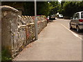
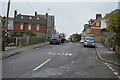
Swanage: stone road-name in Queen?s Road
This frontage wall has a stone stating 'Queen's Road, West Durlston', but is of limited use now owing to both its illegibility and lowness.
Image: © Chris Downer
Taken: 21 Jun 2009
0.07 miles
5
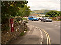
Swanage: postbox № BH19 226, Queen?s Road
This George VI-reign postbox stands on the inside of a bend in Queen's Road, with views across to Nine Barrow Down in the distance. It is emptied finally at 5:30pm on weekdays and at noon on Saturdays.
Image: © Chris Downer
Taken: 21 Jun 2009
0.08 miles
10
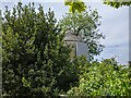
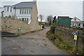
Dovecote (?) in the grounds of Purbeck House
Somewhat dilapidated and boarded up, this seems to be a dovecote in the garden of Purbeck House - now a hotel (the house, not the dovecote!)
Image: © John Lindsay
Taken: 11 Jun 2021
0.13 miles