IMAGES TAKEN NEAR TO
Durlston Road, SWANAGE, BH19 2DJ
Introduction
This page details the photographs taken nearby to Durlston Road, BH19 2DJ by members of the Geograph project.
The Geograph project started in 2005 with the aim of publishing, organising and preserving representative images for every square kilometre of Great Britain, Ireland and the Isle of Man.

There are currently over 7.5m images from over14,400 individuals and you can help contribute to the project by visiting https://www.geograph.org.uk
Image Map (Loading...)


Getting Data...Please wait
Leaflet Map data © OpenStreetMap
Images are licensed for reuse under creativecommons.org/licenses/by-sa/2.0
Notes
- Clicking on the map will re-center to the selected point.
- The higher the marker number, the further away the image location is from the centre of the postcode.
Image Listing (153 Images Found)
Images are licensed for reuse under creativecommons.org/licenses/by-sa/2.0
Image
Details
Distance
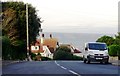
3
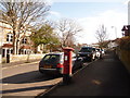
Swanage: postbox № BH19 116, Durlston Road
This Elizabeth II-reign postbox stands on the corner of Bon Accord Road, along which we look, and is emptied finally at 4pm on weekdays and at noon on Saturdays.
Image: © Chris Downer
Taken: 20 Feb 2010
0.07 miles
4
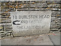
Guidestone, Durlston Road, Swanage
Carved stone guide post in the Parish of Swanage (Purbeck District) on Durlston Road, Swanage, junction with Bon Accord Road, built into garden wall. Erected for local entrepreneur George Burt as part of his abortive scheme to develop the area; late C19th.
Inscription reads:-
TO DURLSTON HEAD
{hand to left} AND CASTLE
THE LARGE GLOBE
AND THE CAVES
Milestone Society National ID: DO_DHLI03.
Image: © Milestone Society
Taken: 31 May 2017
0.08 miles
5
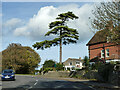
Pine, grounds of Wordsworth House, Swanage
A care home. Oddly it has a minibus inscribed 'Marley House Nursing Home' parked by the tree. That is in Winfrith Newburgh.
Image: © Robin Webster
Taken: 30 Oct 2012
0.08 miles
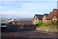
6
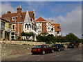
Houses on Durlston Road
These houses on Durlston Road have rather extravagant appendages - turrets and balconies and so on.
Image: © Jim Champion
Taken: 27 Oct 2008
0.11 miles
7
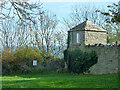
Gazebo, Swanage
In the corner of a garden, placed for good views to sea, but the trees have got in the way.
Image: © Robin Webster
Taken: 30 Oct 2012
0.12 miles
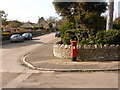
8
Swanage: postbox № BH19 123, Park Road
This Edward VII-reign postbox is emptied finally at 4pm on weekdays and at noon on Saturdays.
Image: © Chris Downer
Taken: 20 Feb 2010
0.12 miles
9
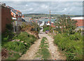
Sentry Road, Swanage
This unsurfaced lane runs steeply down towards the sea. This picture was taken after a night of very heavy rain and a good portion of the track surface was now down in the street below.
Image: © Des Blenkinsopp
Taken: 11 Sep 2011
0.12 miles
10
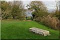
Stone seat without a view
No doubt when this stone seat was installed there was quite a view out to sea across Durlston Bay. Over a century later the vegetation on the upper slopes of the cliff has grown and trees now obscure the view. The coast path goes through the gap in the trees (a causeway across a gully) and on along the clifftop to Peveril Point.
Image: © Jim Champion
Taken: 27 Oct 2008
0.13 miles