IMAGES TAKEN NEAR TO
Taunton Road, SWANAGE, BH19 2BY
Introduction
This page details the photographs taken nearby to Taunton Road, BH19 2BY by members of the Geograph project.
The Geograph project started in 2005 with the aim of publishing, organising and preserving representative images for every square kilometre of Great Britain, Ireland and the Isle of Man.

There are currently over 7.5m images from over14,400 individuals and you can help contribute to the project by visiting https://www.geograph.org.uk
Image Map (794 Images)


Getting Data...Please wait
Leaflet Map data © OpenStreetMap
Images are licensed for reuse under creativecommons.org/licenses/by-sa/2.0
Notes
- Clicking on the map will re-center to the selected point.
- The higher the marker number, the further away the image location is from the centre of the postcode.
Image Listing (794 Images Found)
Images are licensed for reuse under creativecommons.org/licenses/by-sa/2.0
Image
Details
Distance
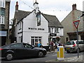
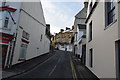
3

The Ship Inn, 23A High Street, Swanage
Grade II Listed hotel incorporating, either side of the 18th century centre section, previously separate early 19th century buildings to the east and west. Signage claims the inn to have been established in 1793. The following landlords are listed in directories, 1842-1844 William Trevers, 1851-1859 Joseph Biddlecombe, 1875 John King (hotel and posting house), 1889 William Cave, 1895 Richard Clark, 1911 Charles H Matthews, 1915 Charles H Matthews.
Image: © Jo and Steve Turner
Taken: 24 Aug 2021
0.02 miles
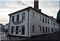
5
![Swanage buildings [2]](https://s3.geograph.org.uk/geophotos/06/78/54/6785499_644d806a_120x120.jpg)
Swanage buildings [2]
The Ship Inn, number 23 High Street, has several parts. The central section is 18th century with rendered stone walls, The eastern and western sections are 19th century with rendered stone walls. The eastern section is now a co-joined business - The Old Brick Piazza Company. The inn incorporates a formerly separate building facing Taunton Road and there are new additions attached thereto. Listed, grade II, with details at: https://historicengland.org.uk/listing/the-list/list-entry/1323602
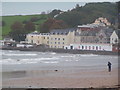
Swanage is a coastal town in the Isle of Purbeck, some 6 miles south of Poole and 25 miles east of Dorchester. Originally a small port and fishing village the town flourished in the Victorian era after the arrival of the railway and it first became a significant quarrying port and later a seaside resort. Tourism is an important part of the economy albeit seasonal and residents commute to Poole and Bournemouth for permanent employment. The town is the terminus of the heritage Swanage Railway.
Image: © Michael Dibb
Taken: 12 Dec 2020
0.02 miles
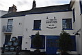
6
![Swanage buildings [1]](https://s2.geograph.org.uk/geophotos/06/78/54/6785498_4b652120_120x120.jpg)
Swanage buildings [1]
The White Swan, number 33 High Street, was built in the late 17th or early 18th century with stuccoed stone walls. There is a rear wing, facing Stafford Road, which was probably originally 18th century cottages. Listed, grade II, with details at: https://historicengland.org.uk/listing/the-list/list-entry/1152585
Swanage is a coastal town in the Isle of Purbeck, some 6 miles south of Poole and 25 miles east of Dorchester. Originally a small port and fishing village the town flourished in the Victorian era after the arrival of the railway and it first became a significant quarrying port and later a seaside resort. Tourism is an important part of the economy albeit seasonal and residents commute to Poole and Bournemouth for permanent employment. The town is the terminus of the heritage Swanage Railway.
Image: © Michael Dibb
Taken: 12 Dec 2020
0.02 miles
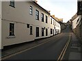
10
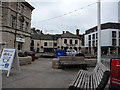
Pedestrianised area outside Swanage Heritage Centre
Image: © Phil Champion
Taken: 22 Sep 2009
0.02 miles