IMAGES TAKEN NEAR TO
Peveril Point Road, SWANAGE, BH19 2AX
Introduction
This page details the photographs taken nearby to Peveril Point Road, BH19 2AX by members of the Geograph project.
The Geograph project started in 2005 with the aim of publishing, organising and preserving representative images for every square kilometre of Great Britain, Ireland and the Isle of Man.

There are currently over 7.5m images from over14,400 individuals and you can help contribute to the project by visiting https://www.geograph.org.uk
Image Map
Images are licensed for reuse under creativecommons.org/licenses/by-sa/2.0
Notes
- Clicking on the map will re-center to the selected point.
- The higher the marker number, the further away the image location is from the centre of the postcode.
Image Listing (275 Images Found)
Images are licensed for reuse under creativecommons.org/licenses/by-sa/2.0
Image
Details
Distance
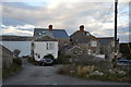
1

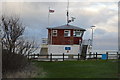
Shelter / lookout at Peveril Point, Swanage
A concrete structure from WWII, now housing displays about the coast.
Image: © Phil Champion
Taken: 12 Sep 2018
0.01 miles
3
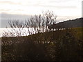
Swanage: bushes in silhouette
Looking towards Durlston Head from Peveril Point, the view of the sun glistening on the water interrupted by these bushes.
Image: © Chris Downer
Taken: 20 Feb 2010
0.01 miles
4
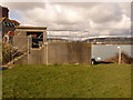
Swanage: concrete lookout at Peveril Point
A rather ugly building at Peveril Point, but the spectacular views available from it, and the shelter it provides from the elements, make up for it.
Image: © Chris Downer
Taken: 20 Feb 2010
0.01 miles
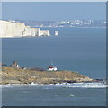
5

Swanage: Peveril Point
Looking along the path following the southern cliff of Peveril Point towards the tip. The cliffs of the Isle of Wight can be seen top-right.
Image: © Chris Downer
Taken: 20 Feb 2010
0.02 miles
6
Lookout Station on Pevril Point
From one of the viewing platforms at Durlston Castle.
Behind are Old Harry's Rocks and the centre of Bournemouth.
Image: © David Lally
Taken: 22 Feb 2014
0.02 miles
7

Swanage: helipad at Peveril Point
A helicopter landing point on Peveril Point, with the Isle of Wight in the distance.
Image: © Chris Downer
Taken: 20 Feb 2010
0.02 miles
9
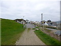
Swanage, gate
The road from the lookout station joins Peveril Point Road.
Image: © Mike Faherty
Taken: 16 Mar 2012
0.02 miles
10
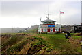
Peveril Point
Looking west towards the Coastwatch Lookout Point which is actually in SZ0378. It is manned by volunteers. The grid line runs along the front of the building.
Image: © Nigel Mykura
Taken: 23 Jan 2016
0.02 miles