IMAGES TAKEN NEAR TO
Buck Shore, SWANAGE, BH19 2AW
Introduction
This page details the photographs taken nearby to Buck Shore, BH19 2AW by members of the Geograph project.
The Geograph project started in 2005 with the aim of publishing, organising and preserving representative images for every square kilometre of Great Britain, Ireland and the Isle of Man.

There are currently over 7.5m images from over14,400 individuals and you can help contribute to the project by visiting https://www.geograph.org.uk
Image Map (Loading...)


Getting Data...Please wait
Leaflet Map data © OpenStreetMap
Images are licensed for reuse under creativecommons.org/licenses/by-sa/2.0
Notes
- Clicking on the map will re-center to the selected point.
- The higher the marker number, the further away the image location is from the centre of the postcode.
Image Listing (527 Images Found)
Images are licensed for reuse under creativecommons.org/licenses/by-sa/2.0
Image
Details
Distance
2
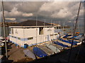
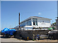
Swanage: Swanage Sailing Club
Situated right by the pier, the sailing club building catches the bright sun while more distant parts sit under ominous clouds.
Image: © Chris Downer
Taken: 20 Feb 2010
0.01 miles
4
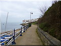
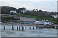
Swanage, coast path
South West Coast Path, looking towards Peveril Point, with Swanage Sailing Club left, and housing at The Haven ahead.
Image: © Mike Faherty
Taken: 16 Mar 2012
0.01 miles
6
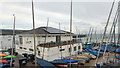
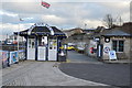
Swanage Sailing Club, Dorset
As seen from the waterfront.
Image: © Christine Matthews
Taken: 26 Apr 2012
0.01 miles
8
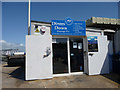
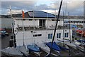
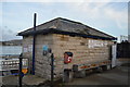
Diving School, Swanage, Pier, Dorset
Image: © Christine Matthews
Taken: 26 Apr 2012
0.02 miles
9
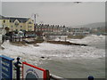
Stormy Swanage
Not much of a day for the sand castle constructors.
Image: © Michael Trolove
Taken: 25 Oct 2006
0.02 miles