IMAGES TAKEN NEAR TO
Seymer Road, SWANAGE, BH19 2AJ
Introduction
This page details the photographs taken nearby to Seymer Road, BH19 2AJ by members of the Geograph project.
The Geograph project started in 2005 with the aim of publishing, organising and preserving representative images for every square kilometre of Great Britain, Ireland and the Isle of Man.

There are currently over 7.5m images from over14,400 individuals and you can help contribute to the project by visiting https://www.geograph.org.uk
Image Map (Loading...)


Getting Data...Please wait
Leaflet Map data © OpenStreetMap
Images are licensed for reuse under creativecommons.org/licenses/by-sa/2.0
Notes
- Clicking on the map will re-center to the selected point.
- The higher the marker number, the further away the image location is from the centre of the postcode.
Image Listing (508 Images Found)
Images are licensed for reuse under creativecommons.org/licenses/by-sa/2.0
Image
Details
Distance
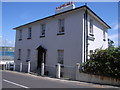
1

Houses on Seymer Road, Swanage
These houses have a spectacular view across Prince Albert Gardens and Swanage Bay.
Image: © David Martin
Taken: 18 Feb 2019
0.01 miles
2
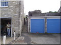
Looking up Piggy Lane
An unofficial? Name to a pathway between the houses.
Am I being threatened with violence by the man on the left?
No, he's just pushed open his garage door.
Image: © Anthony Vosper
Taken: 25 Aug 2011
0.03 miles
4
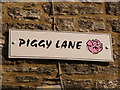
Swanage: Piggy Lane sign
A homemade sign for a little alleyway which may or may not have this name officially.
Image: © Chris Downer
Taken: 20 Feb 2010
0.04 miles
5
Broad Road,Car park
Not sure about this one, but some of the town's parking is a bit costly.
Image: © Anthony Vosper
Taken: 25 Aug 2011
0.04 miles
6
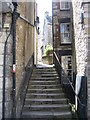
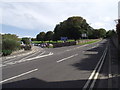
Cliff Place
The steps lead up from the High Street to Sentry Road.
Image: © Mr Ignavy
Taken: 28 Apr 2009
0.04 miles
7
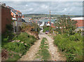
Sentry Road, Swanage
This unsurfaced lane runs steeply down towards the sea. This picture was taken after a night of very heavy rain and a good portion of the track surface was now down in the street below.
Image: © Des Blenkinsopp
Taken: 11 Sep 2011
0.05 miles
8
Imposing house in Seymer Street
Image: © Nick Mutton 01329 000000
Taken: 22 Jun 2008
0.05 miles
9
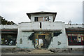
Pier Head building
Although this building is derelict, much of what you see here is an illusion. community artists Shocked Custard have painted murals depicting the past, present, and possible future of this dilapidated building. Built in the 1940s as a mess hall for demobbed Canadian troops, the Pier Head Building was later used as a bingo hall and a wind surfing school before being declared unsafe in the 1990s. The owners have plans to demolish and replace with a new landmark building. http://www.shockedcustard.co.uk/core/pierhead.html
Image: © Phil Champion
Taken: 22 Sep 2009
0.05 miles
10
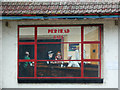
Nighthawks at the Pier Head Cafe
This is the right hand panel on the frontage of the now derelict Image at Swanage. The trompe l'œil mural references Edward Hopper' painting 'Nighthawks', which can be seen on the wall behind. http://www.shockedcustard.co.uk/core/pierhead.html
Image: © Phil Champion
Taken: 22 Sep 2009
0.05 miles