IMAGES TAKEN NEAR TO
Park Road, SWANAGE, BH19 2AB
Introduction
This page details the photographs taken nearby to Park Road, BH19 2AB by members of the Geograph project.
The Geograph project started in 2005 with the aim of publishing, organising and preserving representative images for every square kilometre of Great Britain, Ireland and the Isle of Man.

There are currently over 7.5m images from over14,400 individuals and you can help contribute to the project by visiting https://www.geograph.org.uk
Image Map (Loading...)


Getting Data...Please wait
Leaflet Map data © OpenStreetMap
Images are licensed for reuse under creativecommons.org/licenses/by-sa/2.0
Notes
- Clicking on the map will re-center to the selected point.
- The higher the marker number, the further away the image location is from the centre of the postcode.
Image Listing (758 Images Found)
Images are licensed for reuse under creativecommons.org/licenses/by-sa/2.0
Image
Details
Distance
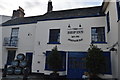
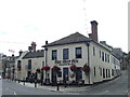
3
![Swanage buildings [3]](https://s0.geograph.org.uk/geophotos/06/78/55/6785500_267145b5_120x120.jpg)
Swanage buildings [3]
The Purbeck Hotel, number 19 High Street, is an early 19th century building in Purbeck stone. The front is symmetrical, with later two-storey bay windows flanking the entrance. Listed, grade II, with details at: https://historicengland.org.uk/listing/the-list/list-entry/1152558
Swanage is a coastal town in the Isle of Purbeck, some 6 miles south of Poole and 25 miles east of Dorchester. Originally a small port and fishing village the town flourished in the Victorian era after the arrival of the railway and it first became a significant quarrying port and later a seaside resort. Tourism is an important part of the economy albeit seasonal and residents commute to Poole and Bournemouth for permanent employment. The town is the terminus of the heritage Swanage Railway.
Image: © Michael Dibb
Taken: 12 Dec 2020
0.01 miles
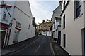
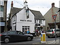
4
High Street, Swanage
From The Square. The Ship is listed and described at https://historicengland.org.uk/listing/the-list/list-entry/1323602 . The K6 telephone box along the street is also listed https://historicengland.org.uk/listing/the-list/list-entry/1323634 . To the right of it is the Purbeck Hotel https://historicengland.org.uk/listing/the-list/list-entry/1152558 .
Image: © Derek Harper
Taken: 4 Apr 2019
0.01 miles
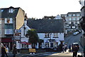
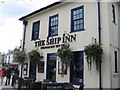
5
The Ship Inn, Swanage
The Ship Inn is a pub in the centre of Swanage, Dorset.
Image: © Malc McDonald
Taken: 17 Aug 2012
0.01 miles
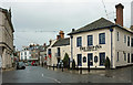
7
![Swanage buildings [2]](https://s3.geograph.org.uk/geophotos/06/78/54/6785499_644d806a_120x120.jpg)
Swanage buildings [2]
The Ship Inn, number 23 High Street, has several parts. The central section is 18th century with rendered stone walls, The eastern and western sections are 19th century with rendered stone walls. The eastern section is now a co-joined business - The Old Brick Piazza Company. The inn incorporates a formerly separate building facing Taunton Road and there are new additions attached thereto. Listed, grade II, with details at: https://historicengland.org.uk/listing/the-list/list-entry/1323602
Swanage is a coastal town in the Isle of Purbeck, some 6 miles south of Poole and 25 miles east of Dorchester. Originally a small port and fishing village the town flourished in the Victorian era after the arrival of the railway and it first became a significant quarrying port and later a seaside resort. Tourism is an important part of the economy albeit seasonal and residents commute to Poole and Bournemouth for permanent employment. The town is the terminus of the heritage Swanage Railway.
Image: © Michael Dibb
Taken: 12 Dec 2020
0.01 miles
8
The Ship Inn, Swanage
Had a pint of Purbeck IPA
Image: © Alex McGregor
Taken: 29 Aug 2010
0.01 miles
9
High Street - Swanage
View from the eastern end, close to the pier.
Image: © Mr Ignavy
Taken: 28 Apr 2009
0.01 miles