IMAGES TAKEN NEAR TO
Northbrook Road, SWANAGE, BH19 1PW
Introduction
This page details the photographs taken nearby to Northbrook Road, BH19 1PW by members of the Geograph project.
The Geograph project started in 2005 with the aim of publishing, organising and preserving representative images for every square kilometre of Great Britain, Ireland and the Isle of Man.

There are currently over 7.5m images from over14,400 individuals and you can help contribute to the project by visiting https://www.geograph.org.uk
Image Map
Images are licensed for reuse under creativecommons.org/licenses/by-sa/2.0
Notes
- Clicking on the map will re-center to the selected point.
- The higher the marker number, the further away the image location is from the centre of the postcode.
Image Listing (665 Images Found)
Images are licensed for reuse under creativecommons.org/licenses/by-sa/2.0
Image
Details
Distance
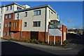
1
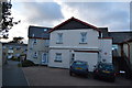
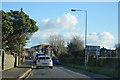
Victoria Avenue, Swanage
Some large houses line the main road to the beach.
Image: © Tony Atkin
Taken: 8 Jun 2011
0.05 miles
3
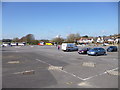
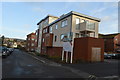
Swanage, car park
Main Beach Longstay Car and Coach Park, off Victoria Avenue.
Image: © Mike Faherty
Taken: 21 Mar 2012
0.05 miles
5
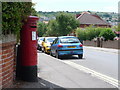
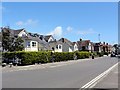
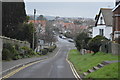
Swanage: postbox № BH19 140, Northbrook Road
Looking south along Northbrook Road from the Walrond Road crossroads, past this postbox which receives its final collections at 4pm on weekdays and at noon on Saturdays.
Image: © Chris Downer
Taken: 21 Jun 2009
0.09 miles
7
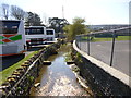
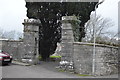
Swanage, Swan Brook
Looking downstream, with Main Beach Car Park left, and Forres Sports Field right.
Image: © Mike Faherty
Taken: 21 Mar 2012
0.09 miles