IMAGES TAKEN NEAR TO
De Moulham Road, SWANAGE, BH19 1NT
Introduction
This page details the photographs taken nearby to De Moulham Road, BH19 1NT by members of the Geograph project.
The Geograph project started in 2005 with the aim of publishing, organising and preserving representative images for every square kilometre of Great Britain, Ireland and the Isle of Man.

There are currently over 7.5m images from over14,400 individuals and you can help contribute to the project by visiting https://www.geograph.org.uk
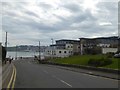
Image Map
Images are licensed for reuse under creativecommons.org/licenses/by-sa/2.0
Notes
- Clicking on the map will re-center to the selected point.
- The higher the marker number, the further away the image location is from the centre of the postcode.
Image Listing (132 Images Found)
Images are licensed for reuse under creativecommons.org/licenses/by-sa/2.0
Image
Details
Distance
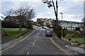
6
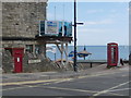
Swanage: postbox № BH19 70, Ulwell Road
This large Edward VII-reign wall box is situated at the foot of Ulwell Road, the main road north out of Swanage, just where it parts from the coastline. It is emptied finally at 5:30pm on weekdays and at noon on Saturdays.
Image: © Chris Downer
Taken: 21 Jun 2009
0.08 miles
7
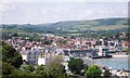
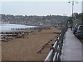
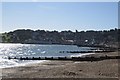
Swanage from the high ground
Picture taken from the high ground overlooking Durlston bay.
Image: © Colin Babb
Taken: 14 Jun 2005
0.08 miles
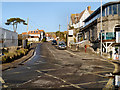
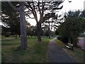
9
Looking down Ulwell road to Swanage Bay
Image: © David Smith
Taken: 30 Mar 2017
0.08 miles
