IMAGES TAKEN NEAR TO
Ulwell Road, SWANAGE, BH19 1LQ
Introduction
This page details the photographs taken nearby to Ulwell Road, BH19 1LQ by members of the Geograph project.
The Geograph project started in 2005 with the aim of publishing, organising and preserving representative images for every square kilometre of Great Britain, Ireland and the Isle of Man.

There are currently over 7.5m images from over14,400 individuals and you can help contribute to the project by visiting https://www.geograph.org.uk
Image Map (Loading...)


Getting Data...Please wait
Leaflet Map data © OpenStreetMap
Images are licensed for reuse under creativecommons.org/licenses/by-sa/2.0
Notes
- Clicking on the map will re-center to the selected point.
- The higher the marker number, the further away the image location is from the centre of the postcode.
Image Listing (57 Images Found)
Images are licensed for reuse under creativecommons.org/licenses/by-sa/2.0
Image
Details
Distance
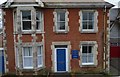
1
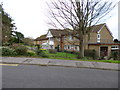
New Swanage, disused care home
Formerly the James Day Care Home, now closed, though there are plans for it to be taken over and re-opened: http://www.bournemouthecho.co.uk/news/9273396.Closed_Swanage_care_home_brought_back_to_life/ According to posters in the windows, the property is now used by a company offering cheap accommodation, to discourage squatters: http://uk.cameloteurope.com/
Image: © Mike Faherty
Taken: 17 Mar 2012
0.00 miles
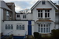
2
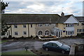
Chatsworth Centre
A residential field studies centre. http://allnatt.co.uk/our-centres/swanage/
Image: © N Chadwick
Taken: 30 Dec 2014
0.01 miles
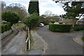
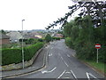
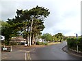
4
New Swanage, one-way system
Because of the width of Ulwell Road at this point, southbound traffic goes left, and northbound comes from the right.
Image: © Mike Faherty
Taken: 17 Mar 2012
0.04 miles
5
Chatsworth Centre
A residential field studies centre. http://allnatt.co.uk/our-centres/swanage/
Image: © N Chadwick
Taken: 30 Dec 2014
0.04 miles
6
Chatsworth Centre
A residential field studies centre. http://allnatt.co.uk/our-centres/swanage/
Image: © N Chadwick
Taken: 30 Dec 2014
0.04 miles
7
Chatsworth Centre
Field studies centre. http://allnatt.co.uk/our-centres/swanage/
Image: © N Chadwick
Taken: 30 Dec 2014
0.05 miles
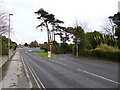
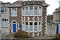
8
Ulwell Road, Swanage
Ulwell Road is a one-way street on the outskirts of Swanage on the Dorset coast.
Image: © Malc McDonald
Taken: 17 Aug 2012
0.05 miles
10
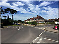
Junction of Ulwell Road and Redcliffe Road, Swanage
Image: © John Allan
Taken: 22 May 2017
0.06 miles