IMAGES TAKEN NEAR TO
Hanbury Road, SWANAGE, BH19 1JA
Introduction
This page details the photographs taken nearby to Hanbury Road, BH19 1JA by members of the Geograph project.
The Geograph project started in 2005 with the aim of publishing, organising and preserving representative images for every square kilometre of Great Britain, Ireland and the Isle of Man.

There are currently over 7.5m images from over14,400 individuals and you can help contribute to the project by visiting https://www.geograph.org.uk
Image Map
Images are licensed for reuse under creativecommons.org/licenses/by-sa/2.0
Notes
- Clicking on the map will re-center to the selected point.
- The higher the marker number, the further away the image location is from the centre of the postcode.
Image Listing (379 Images Found)
Images are licensed for reuse under creativecommons.org/licenses/by-sa/2.0
Image
Details
Distance
2
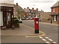
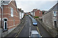
Swanage: postbox № BH19 121, King?s Road West
An Edward VII-reign postbox on the corner of Argyle Road, emptied finally at 5:15pm on weekdays and at noon on Saturdays.
Image: © Chris Downer
Taken: 21 Jun 2009
0.04 miles
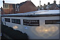
4
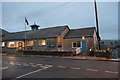
Swanage, Royal British Legion
Earl Haig Memorial, on High Street. http://rblswanage.co.uk/
Image: © Mike Faherty
Taken: 21 Mar 2012
0.04 miles
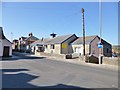
7
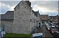
Swanage: the police station
Swanage police station is in Argyle Road, dated 1896 on the date-stone, and is made of Purbeck stone – as is much of Swanage.
Image: © Chris Downer
Taken: 21 Jun 2009
0.04 miles