IMAGES TAKEN NEAR TO
Kings Road West, SWANAGE, BH19 1HE
Introduction
This page details the photographs taken nearby to Kings Road West, BH19 1HE by members of the Geograph project.
The Geograph project started in 2005 with the aim of publishing, organising and preserving representative images for every square kilometre of Great Britain, Ireland and the Isle of Man.

There are currently over 7.5m images from over14,400 individuals and you can help contribute to the project by visiting https://www.geograph.org.uk
Image Map (Loading...)


Getting Data...Please wait
Leaflet Map data © OpenStreetMap
Images are licensed for reuse under creativecommons.org/licenses/by-sa/2.0
Notes
- Clicking on the map will re-center to the selected point.
- The higher the marker number, the further away the image location is from the centre of the postcode.
Image Listing (1045 Images Found)
Images are licensed for reuse under creativecommons.org/licenses/by-sa/2.0
Image
Details
Distance
2
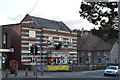
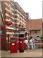
Swanage: the post office
The main post office in Swanage appears not to have an entrance! I believe it is through the Hallmark card shop.
Image: © Chris Downer
Taken: 21 Jun 2009
0.01 miles
3
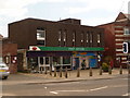
Swanage: postbox №s BH19 300 and BH19 578, Kings Road West
These two postboxes stand outside Image The right-hand one is for stamped mail and the left-hand one for franked mail. They are emptied at 5:45pm on weekdays and at 1pm on Saturdays.
The frontage of the town's Conservative Club is seen behind.
Image: © Chris Downer
Taken: 21 Jun 2009
0.01 miles
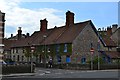
8
![Swanage houses [4]](https://s2.geograph.org.uk/geophotos/06/78/72/6787250_5c2a926c_120x120.jpg)
Swanage houses [4]
Odd numbers 15 to 21 Kings Road East are a terrace of four estate houses built for the third Earl of Eldon in 1894. Built in rock faced coursed limestone. Number 15 is of three bays, the others of two bays. Listed, grade II, with details at: https://historicengland.org.uk/listing/the-list/list-entry/1390541
Swanage is a coastal town in the Isle of Purbeck, some 6 miles south of Poole and 25 miles east of Dorchester. Originally a small port and fishing village the town flourished in the Victorian era after the arrival of the railway and it first became a significant quarrying port and later a seaside resort. Tourism is an important part of the economy albeit seasonal and residents commute to Poole and Bournemouth for permanent employment. The town is the terminus of the heritage Swanage Railway.
Image: © Michael Dibb
Taken: 12 Dec 2020
0.02 miles