IMAGES TAKEN NEAR TO
Gaskell Close, BH19 1FH
Introduction
This page details the photographs taken nearby to Gaskell Close, BH19 1FH by members of the Geograph project.
The Geograph project started in 2005 with the aim of publishing, organising and preserving representative images for every square kilometre of Great Britain, Ireland and the Isle of Man.

There are currently over 7.5m images from over14,400 individuals and you can help contribute to the project by visiting https://www.geograph.org.uk
Image Map (Loading...)


Getting Data...Please wait
Leaflet Map data © OpenStreetMap
Images are licensed for reuse under creativecommons.org/licenses/by-sa/2.0
Notes
- Clicking on the map will re-center to the selected point.
- The higher the marker number, the further away the image location is from the centre of the postcode.
Image Listing (4 Images Found)
Images are licensed for reuse under creativecommons.org/licenses/by-sa/2.0
Image
Details
Distance
1
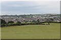
Fields Above Swanage
Looking down onto Swanage from raised ground to the north on the road towards Ulwell
Image: © Nigel Mykura
Taken: 5 Sep 2016
0.20 miles
2
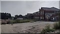
Old Swanage Grammar School
The old Swanage Grammar School with the site now being redeveloped for housing
Image: © Shaun Ferguson
Taken: 5 Sep 2021
0.22 miles
3
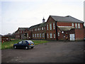
The Old Grammar School, Swanage
Swanage Grammar School in Northbrook Road opened in 1929 and closed down in 1973 with the coming of comprehensive education and the opening of the Purbeck School in Wareham. The building's future remains uncertain, as plans to convert it into holiday homes have been repeatedly rejected.
http://www.beond.co.uk/SGSA/index.html
Image: © John Lamper
Taken: 17 Jan 2006
0.22 miles
4
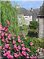
Mill Pond, Swanage
Taken early morning in July.
Image: © Alan hodgson
Taken: 14 Jul 2006
0.25 miles