IMAGES TAKEN NEAR TO
Lancaster Drive, BROADSTONE, BH18 9EL
Introduction
This page details the photographs taken nearby to Lancaster Drive, BH18 9EL by members of the Geograph project.
The Geograph project started in 2005 with the aim of publishing, organising and preserving representative images for every square kilometre of Great Britain, Ireland and the Isle of Man.

There are currently over 7.5m images from over14,400 individuals and you can help contribute to the project by visiting https://www.geograph.org.uk
Image Map (Loading...)


Getting Data...Please wait
Leaflet Map data © OpenStreetMap
Images are licensed for reuse under creativecommons.org/licenses/by-sa/2.0
Notes
- Clicking on the map will re-center to the selected point.
- The higher the marker number, the further away the image location is from the centre of the postcode.
Image Listing (28 Images Found)
Images are licensed for reuse under creativecommons.org/licenses/by-sa/2.0
Image
Details
Distance
1

Snow in summer
This flower called 'snow-in-summer' grows on a front wall in Sutherland Avenue
Image: © John Palmer
Taken: 12 May 2008
0.08 miles
2
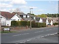
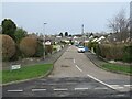
Lancaster Drive, Broadstone
Lancaster Drive is long and climbs, this is the top where it crosses the Roman Road, forming the border between Broadstone and Corfe Mullen. The houses were built about 1980, I can remember when all this was heathland. Behind the houses is Corfe Hills School and its playing field.
Image: © John Palmer
Taken: 4 Apr 2009
0.08 miles
3

Triple parking in Suburbia
Back streets in Suburbia have become car parks, because garages are used as junk store rooms, because houses are too small, because there's not enough land for our huge population.....May-day! May-day!
Image: © John Palmer
Taken: 1 May 2009
0.08 miles
4
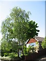
Birch and maple in the front garden
These trees make a landmark when entering Sutherland Avenue from the North.
They are 30 years old.
Image: © John Palmer
Taken: 12 May 2008
0.08 miles
5
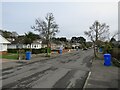
Lancaster Drive, Broadstone
Lancaster Drive is a residential road in Broadstone, on the outskirts of Poole.
Image: © Malc McDonald
Taken: 7 Feb 2022
0.09 miles
6
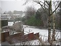
Snow in Sutherland Avenue
We woke to find snow on the front garden
Image: © John Palmer
Taken: 6 Feb 2009
0.09 miles
7
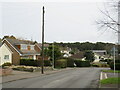
Holland Way, Broadstone
Holland way is a residential road in Broadstone, on the outskirts of Poole.
Image: © Malc McDonald
Taken: 7 Feb 2022
0.10 miles
8
Anvil Crescent, Broadstone
Anvil Crescent is a residential road in Broadstone, in the outskirts of Poole.
This image was taken on an early February day. Trees by the kerbside were bare for the winter months.
Image: © Malc McDonald
Taken: 7 Feb 2022
0.11 miles
9
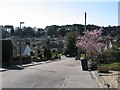
Sutherland Avenue, Broadstone
Looking South, lovely March day, prunus out, the start of a 7 mile walk
DW76
Image: © John Palmer
Taken: 30 Mar 2009
0.12 miles
10
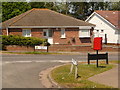
Broadstone: postbox № BH18 212, Lancaster Drive
This small postbox is right on the Poole borough boundary, the boundary being Roman Road, in which we are stood. The Roman Road sign in front of us is an East Dorset one; the Lancaster Drive signs beyond are those of Poole Borough.
The BH21 (Wimborne) area is to the left, with BH18 (Broadstone, part of Poole borough but postally separate) to the right. The postal boundary does not quite match the borough one all the way down Roman Road, thanks to short culs-de-sac off to the west which are obviously better served from the east.
The box is emptied at 5:30 on weekday evenings and at 11:45 on Saturday mornings.
Image: © Chris Downer
Taken: 24 May 2009
0.12 miles