IMAGES TAKEN NEAR TO
Whitby Avenue, BROADSTONE, BH18 8HL
Introduction
This page details the photographs taken nearby to Whitby Avenue, BH18 8HL by members of the Geograph project.
The Geograph project started in 2005 with the aim of publishing, organising and preserving representative images for every square kilometre of Great Britain, Ireland and the Isle of Man.

There are currently over 7.5m images from over14,400 individuals and you can help contribute to the project by visiting https://www.geograph.org.uk
Image Map
Images are licensed for reuse under creativecommons.org/licenses/by-sa/2.0
Notes
- Clicking on the map will re-center to the selected point.
- The higher the marker number, the further away the image location is from the centre of the postcode.
Image Listing (11 Images Found)
Images are licensed for reuse under creativecommons.org/licenses/by-sa/2.0
Image
Details
Distance
1
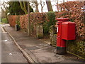
Broadstone: postbox № BH18 161, York Road
This Elizabeth II-reign postbox is emptied finally at 5:30pm on weekdays and at 11:30am on Saturdays.
Image: © Chris Downer
Taken: 2 Apr 2010
0.12 miles
2
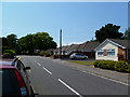
Waterloo, bungalows
On York Road, near the junction with Sopers Lane.
Image: © Mike Faherty
Taken: 3 Jul 2011
0.14 miles
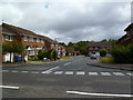
3

Chaffinch Close, Broadstone
All the streets in this very suburban part of Poole are named after common birds.
Image: © Nigel Mykura
Taken: 22 Nov 2009
0.14 miles
4
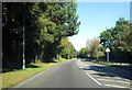
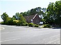
Broadstone Way
This fast road was built on the alignment of the former LSWR line into Bournemouth West from Broadstone.
Image: © Peter Kazmierczak
Taken: 28 Oct 2011
0.19 miles
5
Pinesprings, Chaffinch Close
Side road off Beechbank Avenue; like most other roads on this part of the estate, named after native wild birds.
Image: © Mike Faherty
Taken: 22 Jun 2011
0.20 miles
6
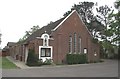
Hillbourne, Catholic Church
St. Anthony of Padua Catholic Church, at the corner of York and Hillbourne Roads.
Image: © Mike Faherty
Taken: 3 Jul 2011
0.22 miles
7

Pinesprings, railway trackbed
Once the Southampton to Dorchester railway, nicknamed "Castleman Corkscrew" because of its sinuous route; now the Castleman Trailway: http://www.dorsetforyou.com/castlemantrailway
Image: © Mike Faherty
Taken: 22 Jun 2011
0.22 miles
8
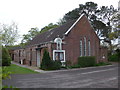
St Anthony of Padua Roman Catholic Church
Although in the district of Hillbourne, the church also serves Broadstone, 1 km to the north.
Image: © mike smith
Taken: 22 Apr 2007
0.22 miles
9
In which I Poole my resources (2)
St Anthony of Padua (RC), Hillbourne
Image: © Basher Eyre
Taken: 22 Apr 2014
0.22 miles
10
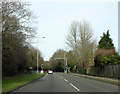
On Broadstone Way
Broadstone Way, laid on the trackbed of the former London & South Western Railway line.
Image: © Peter Kazmierczak
Taken: 29 Feb 2016
0.23 miles