IMAGES TAKEN NEAR TO
Verity Crescent, POOLE, BH17 8TH
Introduction
This page details the photographs taken nearby to Verity Crescent, BH17 8TH by members of the Geograph project.
The Geograph project started in 2005 with the aim of publishing, organising and preserving representative images for every square kilometre of Great Britain, Ireland and the Isle of Man.

There are currently over 7.5m images from over14,400 individuals and you can help contribute to the project by visiting https://www.geograph.org.uk
Image Map
Images are licensed for reuse under creativecommons.org/licenses/by-sa/2.0
Notes
- Clicking on the map will re-center to the selected point.
- The higher the marker number, the further away the image location is from the centre of the postcode.
Image Listing (3 Images Found)
Images are licensed for reuse under creativecommons.org/licenses/by-sa/2.0
Image
Details
Distance
1
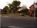
Canford Heath: postbox № BH17 326, Verity Crescent
This large, Elizabeth II-reign postbox is at the corner of the long Verity Crescent and Adastral Road, the central thoroughfare through the Canford Heath housing estate. It is emptied finally at 5:30pm on weekdays and at 12:15pm on Saturdays.
Image: © Chris Downer
Taken: 14 Sep 2009
0.03 miles
2
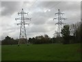
Canford Heath, electricity pylons
Part of a route from Upton to Hamworthy and Longham; as seen from open space next to Sherborn Crescent.
Image: © Mike Faherty
Taken: 27 Nov 2009
0.18 miles
3
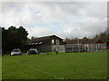
Canford Heath, Scout HQ
Headquarters of Poole North Scout Group, off Sherborn Crescent. http://pnsg.org.uk/
Image: © Mike Faherty
Taken: 27 Nov 2009
0.22 miles