IMAGES TAKEN NEAR TO
Nicholson Close, POOLE, BH17 8PS
Introduction
This page details the photographs taken nearby to Nicholson Close, BH17 8PS by members of the Geograph project.
The Geograph project started in 2005 with the aim of publishing, organising and preserving representative images for every square kilometre of Great Britain, Ireland and the Isle of Man.

There are currently over 7.5m images from over14,400 individuals and you can help contribute to the project by visiting https://www.geograph.org.uk
Image Map
Images are licensed for reuse under creativecommons.org/licenses/by-sa/2.0
Notes
- Clicking on the map will re-center to the selected point.
- The higher the marker number, the further away the image location is from the centre of the postcode.
Image Listing (13 Images Found)
Images are licensed for reuse under creativecommons.org/licenses/by-sa/2.0
Image
Details
Distance
1
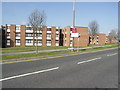
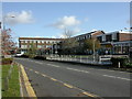
Apartment Blocks in Canford Heath
These are on Adastral Road, opposite Adastral Square.
Image: © mike smith
Taken: 9 Apr 2007
0.13 miles
2
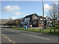
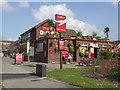
Canford Heath, The Pilot
Pub on Adastral Road, next to the shopping centre. Since it was first photographed (Image), the pub has changed hands and signage. Cask ales on offer at my visit: Ringwood Best, Forty Niner. For some customer comments, see http://www.beerintheevening.com/pubs/s/43/4363/Pilot/Canford_Heath
Image: © Mike Faherty
Taken: 5 Nov 2009
0.16 miles
3
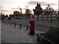
Canford Heath: postbox № BH17 281, Adastral Road
This large postbox faces Image and is emptied finally at 5:30pm on weekdays and at noon on Saturdays.
Image: © Chris Downer
Taken: 14 Sep 2009
0.16 miles
4
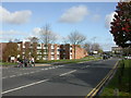
Canford Heath, Downland Place Estate
Privately-owned estate of apartment blocks on Adastral Road.
Image: © Mike Faherty
Taken: 5 Nov 2009
0.17 miles
6
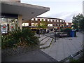
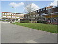
Canford Heath: Adastral Square
This shopping centre, actually more of a triangle than a square, provides a good variety of outlets serving the southern, older section of the vast Canford Heath housing estate. There are a Chinese and an Indian takeaway, a bookmaker, chemist, a couple of estate agents and, far right, the Somerfield supermarket. There was a post office here too – it was not on the 2008 national hit-list for closure so I presume it has closed since and under different circumstances.
Image: © Chris Downer
Taken: 14 Sep 2009
0.17 miles
7
Typical Modern Housing in Canford Heath
These homes are on the southern end of Adastral Road.
Image: © mike smith
Taken: 9 Apr 2007
0.17 miles
8
Canford Heath, shopping centre
On Adastral Road; currently, supermarket, 2 estate agents, Chinese take-away, launderette, fish & chip shop, Indian restaurant, betting shop, barbers, charity shop, pharmacy and one empty property.
Image: © Mike Faherty
Taken: 5 Nov 2009
0.18 miles
9
Shops on Adastral Road
This is the closest you get to the "centre" of Canford Heath.
Image: © mike smith
Taken: 9 Apr 2007
0.18 miles
10
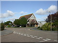
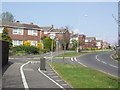
Canford Heath Church
At the junction of Scarf and Mitchell Roads. http://www.churc.co.uk/
Image: © Mike Faherty
Taken: 5 Nov 2009
0.20 miles