IMAGES TAKEN NEAR TO
Meadowsweet Road, POOLE, BH17 7XY
Introduction
This page details the photographs taken nearby to Meadowsweet Road, BH17 7XY by members of the Geograph project.
The Geograph project started in 2005 with the aim of publishing, organising and preserving representative images for every square kilometre of Great Britain, Ireland and the Isle of Man.

There are currently over 7.5m images from over14,400 individuals and you can help contribute to the project by visiting https://www.geograph.org.uk
Image Map
Images are licensed for reuse under creativecommons.org/licenses/by-sa/2.0
Notes
- Clicking on the map will re-center to the selected point.
- The higher the marker number, the further away the image location is from the centre of the postcode.
Image Listing (15 Images Found)
Images are licensed for reuse under creativecommons.org/licenses/by-sa/2.0
Image
Details
Distance
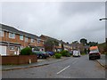
1
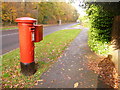
Creekmoor: postbox № BH17 198, Longmeadow Lane
This George V-reign postbox stands in Longmeadow Lane, at the western extremity of a large housing estate built in the 1970s and early 80s – this is therefore not its original location! It is emptied finally at 5:30pm on weekdays and at 12:15pm on Saturdays.
Ahead of us is the junction of Meadowsweet Road.
Image: © Chris Downer
Taken: 15 Nov 2009
0.08 miles
2
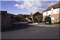
Larch Close, Creekmoor, Poole, Dorset
Many of the roads in Creekmoor are named after trees, birds or flowers.
Image: © John Lamper
Taken: 25 Nov 2005
0.13 miles
3
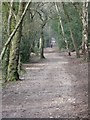
Roman Road, Upton Heath
The Roman Road heading North from Poole Harbour. Once thousands of Roman soldiers marched across a lonely heathland in a foreign country.
Image: © John Palmer
Taken: 3 Apr 2009
0.13 miles
4
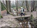
Footbridge , Upton Heath
A handy footbridge among the trees, on the edge of Upton Heath, where it meets the houses of Creekmoor.
Image: © John Palmer
Taken: 3 Apr 2009
0.15 miles
5
Blackbird Close, Creekmoor
One of the many small roads on this residential estate in Poole, named after bird. It is just off woodpecker Drive.
Image: © Nigel Mykura
Taken: 21 Nov 2009
0.18 miles
6
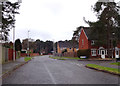
Woodpecker Drive, Creekmoor
Suburban housing estate on the edge of Poole.
Image: © Peter Kazmierczak
Taken: 4 Apr 2016
0.18 miles
7
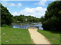
Creekmoor Ponds, fishing platform
Looking across the eastern pond, a former sandpit.
Image: © Mike Faherty
Taken: 21 Jun 2011
0.19 miles
8
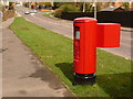
Creekmoor: postbox № BH17 270, Beechbank Avenue
This modern postbox serves the 1980s housing estate of western Creekmoor, and is emptied finally at 5:30pm on weekdays and at 12:15pm on Saturdays.
Image: © Chris Downer
Taken: 2 Apr 2010
0.21 miles
9
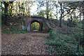
Railway arch, Upton Heath
The ancient Roman Road passes underneath the dismantled Southampton & Dorchester Railway. The Roman Road connected Hamworthy, on Poole Harbour, with the Roman fortress at Lake on the river Stour near Wimborne.
Image: © John Palmer
Taken: 3 Apr 2009
0.22 miles
10
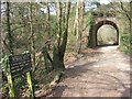
Turf Zone "CastlemanTrai"
Path goes under a former railway bridge.
Image: © Ian S
Taken: 17 Nov 2022
0.22 miles