IMAGES TAKEN NEAR TO
Chetwode Way, POOLE, BH17 7JF
Introduction
This page details the photographs taken nearby to Chetwode Way, BH17 7JF by members of the Geograph project.
The Geograph project started in 2005 with the aim of publishing, organising and preserving representative images for every square kilometre of Great Britain, Ireland and the Isle of Man.

There are currently over 7.5m images from over14,400 individuals and you can help contribute to the project by visiting https://www.geograph.org.uk
Image Map
Images are licensed for reuse under creativecommons.org/licenses/by-sa/2.0
Notes
- Clicking on the map will re-center to the selected point.
- The higher the marker number, the further away the image location is from the centre of the postcode.
Image Listing (25 Images Found)
Images are licensed for reuse under creativecommons.org/licenses/by-sa/2.0
Image
Details
Distance
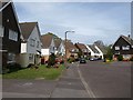
2
Bus stop, Lower Blandford Road
This is the B3074 from Darby's Corner to Broadstone. Past the area of grass and the oak tree is the junction with Okeford Road. Some colourful pink blossom just up the road.
Image: © Derek Harper
Taken: 28 Apr 2010
0.10 miles
3
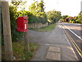
Broadstone: postbox № BH18 122, Lower Blandford Road
This little postbox is close to the southern end of Broadstone, although there is no formal boundary apart from the postal one. It is emptied finally at 5pm on weekdays and at 11:30am on Saturdays.
Image: © Chris Downer
Taken: 12 Jul 2009
0.11 miles
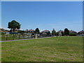
4
Turf Zone "GoughGround"
Park off Gough Crescent, Broadstone.
Image: © Ian S
Taken: 17 Nov 2022
0.14 miles
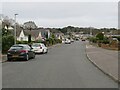
5
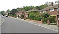
Greenhayes, Broadstone
The southern end of the cul-de-sac off Fontmell Road, seen here from the path approaching from Darby's Corner.
Image: © Derek Harper
Taken: 28 Apr 2010
0.16 miles
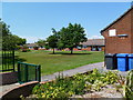
6
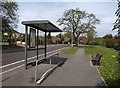
Hillbourne, recreation ground
Between the arms of Gough Crescent; left, play area; right, basketball, football and aerial ropeway.
Image: © Mike Faherty
Taken: 3 Jul 2011
0.16 miles
7
Fontmell Road, Broadstone
Fontmell Road is a residential road in Broadstone.
This image has been edited so that vehicle registration marks cannot be identified, for reasons of data protection.
Image: © Malc McDonald
Taken: 30 Dec 2024
0.16 miles
8
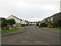
Greenhayes, Broadstone
Greenhayes is a residential cul-de-sac in Broadstone.
Image: © Malc McDonald
Taken: 30 Dec 2024
0.18 miles
9
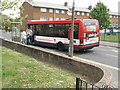
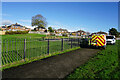
Bus on Milne Road
There appears to be a very frequent Sunday bus service in Hillbourne.
Image: © mike smith
Taken: 22 Apr 2007
0.19 miles
10
Hillbourne, sheltered housing
Waterloo House, on Milne Road. http://www.housingcare.org/housing-care/facility-info-2612-waterloo-house-poole-england.aspx
Image: © Mike Faherty
Taken: 3 Jul 2011
0.20 miles