IMAGES TAKEN NEAR TO
Stalbridge Road, POOLE, BH17 7AT
Introduction
This page details the photographs taken nearby to Stalbridge Road, BH17 7AT by members of the Geograph project.
The Geograph project started in 2005 with the aim of publishing, organising and preserving representative images for every square kilometre of Great Britain, Ireland and the Isle of Man.

There are currently over 7.5m images from over14,400 individuals and you can help contribute to the project by visiting https://www.geograph.org.uk
Image Map
Images are licensed for reuse under creativecommons.org/licenses/by-sa/2.0
Notes
- Clicking on the map will re-center to the selected point.
- The higher the marker number, the further away the image location is from the centre of the postcode.
Image Listing (28 Images Found)
Images are licensed for reuse under creativecommons.org/licenses/by-sa/2.0
Image
Details
Distance
1
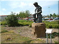
The Craftsman
This statue was commissioned by B&Q (in the background) and unveiled by the Mayor of Poole on 29th April 1999. The sculptor was Kenneth Potts.
Image: © Stuart Buchan
Taken: 19 Jul 2005
0.06 miles
3
Creekmoor Industrial Estate
A small part of the estate, between Creekmoor Lane, Cabot Way and Broadstone Way. This is Holyrood Close.
Image: © Mike Faherty
Taken: 8 Jul 2011
0.13 miles
4

Creekmoor, Makro
Cash and Carry on Holyrood Close, Creekmoor Industrial Estate. http://www.makro.co.uk/servlet/PB/menu/1049611_l2/index.html
Image: © Mike Faherty
Taken: 8 Jul 2011
0.14 miles
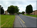
5
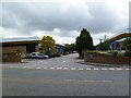
Broadstone Way at Fleetsbridge
Broadstone Way was converted slowly in the 1970s from a railway line to a road connecting Poole and Broadstone The Somerset and Dorset Railway line was closed under Dr Beeching's orders around 1966. In the distance is part of the Fleetsbridge interchange, on the left part of the large Tesco superstore. The oak tree in the centre has seen many big changes in the last 70 years
Image: © John Palmer
Taken: 29 May 2009
0.14 miles
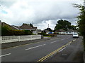
6
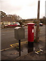
Creekmoor: postbox № BH17 5, Pergin Crescent
This George V-reign postbox is emptied finally at 5:15pm on weekdays and at 12:15pm on Saturdays. Alongside it is a drop box (see below). In the background, we see the A35 Upton Road.
Image: © Chris Downer
Taken: 22 Nov 2009
0.14 miles
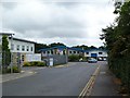
7
Fleetsbridge Business Centre
On Upton Road.
Image: © Mike Faherty
Taken: 8 Jul 2011
0.15 miles
8
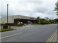
Fleetsbridge, delivery office
Parcelforce delivery office in the Alpha Centre on Upton Road.
Image: © Mike Faherty
Taken: 8 Jul 2011
0.17 miles
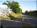
9
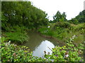
Creekmoor, drainage channel
Almost a scene of rural charm, apart from traffic roaring past. The outfall from Canford Heath and Hatch Pond, seen from Creekmoor Bridge. For a view to the South, see Image
Image: © Mike Faherty
Taken: 8 Jul 2011
0.17 miles
10
Creekmoor, Hazlebury Road
Bungalows off Creekmoor Lane.
Image: © Mike Faherty
Taken: 8 Jul 2011
0.17 miles