IMAGES TAKEN NEAR TO
Darbys Lane North, POOLE, BH17 0RF
Introduction
This page details the photographs taken nearby to Darbys Lane North, BH17 0RF by members of the Geograph project.
The Geograph project started in 2005 with the aim of publishing, organising and preserving representative images for every square kilometre of Great Britain, Ireland and the Isle of Man.

There are currently over 7.5m images from over14,400 individuals and you can help contribute to the project by visiting https://www.geograph.org.uk
Image Map
Images are licensed for reuse under creativecommons.org/licenses/by-sa/2.0
Notes
- Clicking on the map will re-center to the selected point.
- The higher the marker number, the further away the image location is from the centre of the postcode.
Image Listing (18 Images Found)
Images are licensed for reuse under creativecommons.org/licenses/by-sa/2.0
Image
Details
Distance
1

Fleetsbridge, pyramidal orchids
In an unusual site, in the middle of an industrial estate, is a group of pyramidal orchids (Anacamptis pyramidalis). Even more unusually, this species of orchid normally lives on lime; perhaps the explanation is that lime-rich soil or hardcore was imported when the site was being developed.
Image: © Mike Faherty
Taken: 11 Jun 2009
0.04 miles
2
Poole Coastguard station
An unlikely spot for a Coastguard team to be based - the back end of a trading estate about four miles from the sea.
Image: © Stephen Williams
Taken: 19 Feb 2004
0.07 miles
3
Fleetsbridge, bee orchids
In an unusual site, in the middle of an industrial estate, is an apparently thriving colony of bee orchids (Ophrys apifera). Even more unusually, this species of orchid normally lives on lime; perhaps the explanation is that lime-rich soil or hardcore was imported when the site was being developed.
Image: © Mike Faherty
Taken: 11 Jun 2009
0.08 miles
5
Longfleet, industrial estate
A small portion of Nuffield Industrial Estate, between Dorset Way and Waterloo Road; seen here, buildings in Abingdon Road.
Image: © Mike Faherty
Taken: 22 Nov 2009
0.11 miles
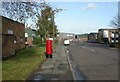
6

Fleetsbridge: postbox № BH17 263, Nuffield Road
This postbox serves the northern part of the Nuffield Industrial Estate and is emptied finally at 6:30pm on weekdays and at 12:30pm on Saturdays.
Image: © Chris Downer
Taken: 27 Jul 2009
0.12 miles
7
Longfleet, postbox
On Cowley Road, Nuffield Industrial Estate, an EIIR suburban-type postbox, ID BH17 263.
Image: © Mike Faherty
Taken: 22 Nov 2009
0.12 miles
8

Fleetsbridge: Dorset Sorting Office
This unit in the Nuffield Industrial Estate is the main sorting office for the BH (Bournemouth) and DT (Dorchester) postcode areas, which between them cover all but the northern fringes of Dorset county along with the southwestern part of Hampshire – as reflected in the postmark 'Dorset & South West Hants' which items coming through here receive.
Image: © Chris Downer
Taken: 27 Jul 2009
0.15 miles
9

Fleetsbridge: Dorset Sorting Office frontage
Detail of the vast frontage of Image, which is catching the late evening sun tonight after an overcast late afternoon.
Image: © Chris Downer
Taken: 27 Jul 2009
0.15 miles
10

Fleetsbridge: postbox № BH17 2000, Witney Road
Given the location of this postbox, at the main entrance of Image, it is not surprising that it has the latest collection times of any postbox in Dorset – 8pm on weekdays and 3:15pm on Saturdays. The left-hand slot is for franked mail, the middle slot for large stamped items and the right-hand for small stamped items (presumably referring to items qualifying for the basic 'letter' rate as opposed to large letter or packet).
Image: © Chris Downer
Taken: 27 Jul 2009
0.15 miles