IMAGES TAKEN NEAR TO
Post Green Road, POOLE, BH16 6JD
Introduction
This page details the photographs taken nearby to Post Green Road, BH16 6JD by members of the Geograph project.
The Geograph project started in 2005 with the aim of publishing, organising and preserving representative images for every square kilometre of Great Britain, Ireland and the Isle of Man.

There are currently over 7.5m images from over14,400 individuals and you can help contribute to the project by visiting https://www.geograph.org.uk
Image Map
Images are licensed for reuse under creativecommons.org/licenses/by-sa/2.0
Notes
- Clicking on the map will re-center to the selected point.
- The higher the marker number, the further away the image location is from the centre of the postcode.
Image Listing (11 Images Found)
Images are licensed for reuse under creativecommons.org/licenses/by-sa/2.0
Image
Details
Distance
1
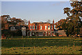
Post Green House, Post Green - Lytchett Minster (2)
The earlier building is apparent from this view of the south elevation of Post Green House. The iron verandah was added later in the C19.
Image: © Mike Searle
Taken: 15 Nov 2007
0.09 miles
2
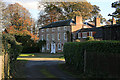
Post Green House, Post Green - Lytchett Minster
A mid to late C18 Grade II* Listed country house, that was considerably enlarged in the early C19. The earlier building is to the rear of the later north elevation seen here Image
Image: © Mike Searle
Taken: 15 Nov 2007
0.12 miles
3
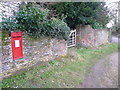
Lytchett Minster: postbox № BH16 180, Post Green Road
This wall-mounted George V-reign postbox is set back from the road slightly.
Image: © Chris Downer
Taken: 17 Jan 2009
0.12 miles
4
Post box on Post Green Road
Box No: BH16 180
Image: © Anthony Vosper
Taken: 26 Aug 2011
0.13 miles
5
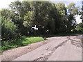
A Dorset finger post, Post Green Road
One of many old style signposts in the area. The circle on top gives a grid reference.
Image: © Anthony Vosper
Taken: 26 Aug 2011
0.16 miles
6
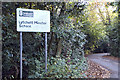
Entrance to Lytchett Minster School, Dorset
Lytchett Minster School is an 11-18 coeducational community school of 1225 students of whom approximately 250 are in the sixth form.
http://www.lytchettminster.dorset.sch.uk/index.htm
Image: © John Lamper
Taken: 20 Nov 2005
0.17 miles
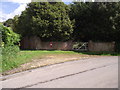
8
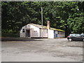
The Parish hall
This somewhat military looking building is undated.
Image: © Anthony Vosper
Taken: 26 Aug 2011
0.23 miles
9
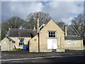
Community centre, Lytchett Minster
This building was at one time the village school. There is an Ordnance Survey flush bracket on the wall, near the white doors.
Image: © Maigheach-gheal
Taken: 26 Feb 2011
0.23 miles
10
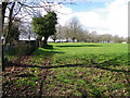
Footpath, Lytchett Minster
There is a short footpath beside the church that takes walkers through a field towards another minor road.
Image: © Maigheach-gheal
Taken: 26 Feb 2011
0.25 miles