IMAGES TAKEN NEAR TO
Bulbury Lane, POOLE, BH16 6HR
Introduction
This page details the photographs taken nearby to Bulbury Lane, BH16 6HR by members of the Geograph project.
The Geograph project started in 2005 with the aim of publishing, organising and preserving representative images for every square kilometre of Great Britain, Ireland and the Isle of Man.

There are currently over 7.5m images from over14,400 individuals and you can help contribute to the project by visiting https://www.geograph.org.uk
Image Map (Loading...)


Getting Data...Please wait
Leaflet Map data © OpenStreetMap
Images are licensed for reuse under creativecommons.org/licenses/by-sa/2.0
Notes
- Clicking on the map will re-center to the selected point.
- The higher the marker number, the further away the image location is from the centre of the postcode.
Image Listing (8 Images Found)
Images are licensed for reuse under creativecommons.org/licenses/by-sa/2.0
Image
Details
Distance
1
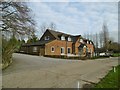
Slepe, clubhouse
At Bulbury Woods Golf Club: http://www.bulbury-woods.co.uk/
Image: © Mike Faherty
Taken: 3 Jan 2019
0.02 miles
2
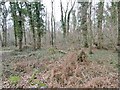
Slepe, coppice
Bulbury Coppice, at Bulbury Woods Golf Club.
Image: © Mike Faherty
Taken: 3 Jan 2019
0.08 miles
3
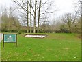
Slepe, golf course
The tenth tee at Bulbury Woods Golf Club, off Bulbury Lane: http://www.bulbury-woods.co.uk/
Image: © Mike Faherty
Taken: 3 Jan 2019
0.09 miles
4
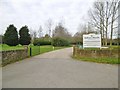
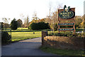
Slepe, club entrance
On Bulbury Lane, the entrance to Bulbury Woods Golf Club: http://www.bulbury-woods.co.uk/
Image: © Mike Faherty
Taken: 3 Jan 2019
0.10 miles
5
Bulbury Woods Golf Course, Dorset
The golf course has panoramic views of the Purbeck Hills and Poole Harbour.
Image: © John Lamper
Taken: 17 Nov 2005
0.10 miles
6
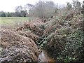
Slepe, ditch
Seen from Bulbury Lane; probably draining into Sherford River, to the South.
Image: © Mike Faherty
Taken: 3 Jan 2019
0.14 miles
7
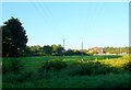
House on Halls Rd
This house is on the small road that leads to Bartons Hill and Dolmans Hill off the Dorchester to Poole road, the A35. The house is surrounded by fields and part of Bulbury Golf Club
Image: © Nigel Mykura
Taken: 28 Sep 2011
0.18 miles
8
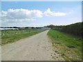
Slepe, access road
Road and bridleway, giving access to the solar farm (left) and Newton Farm; the bridleway continues to Wareham Road.
Image: © Mike Faherty
Taken: 19 Apr 2017
0.24 miles