IMAGES TAKEN NEAR TO
Bartoms Lane, POOLE, BH16 6HN
Introduction
This page details the photographs taken nearby to Bartoms Lane, BH16 6HN by members of the Geograph project.
The Geograph project started in 2005 with the aim of publishing, organising and preserving representative images for every square kilometre of Great Britain, Ireland and the Isle of Man.

There are currently over 7.5m images from over14,400 individuals and you can help contribute to the project by visiting https://www.geograph.org.uk
Image Map (4 Images)


Getting Data...Please wait
Leaflet Map data © OpenStreetMap
Images are licensed for reuse under creativecommons.org/licenses/by-sa/2.0
Notes
- Clicking on the map will re-center to the selected point.
- The higher the marker number, the further away the image location is from the centre of the postcode.
Image Listing (4 Images Found)
Images are licensed for reuse under creativecommons.org/licenses/by-sa/2.0
Image
Details
Distance
1
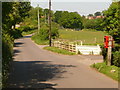
Lytchett Matravers: postbox № BH16 245, Middle Road
A small postbox serving the southwestern periphery of the village; it is emptied finally at 4pm on weekdays and at 10:15 on Saturday mornings.
Image: © Chris Downer
Taken: 24 May 2009
0.11 miles
2
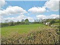
Lytchett Matravers, power lines
Striding across grazing land.
Image: © Mike Faherty
Taken: 19 Apr 2017
0.20 miles
3
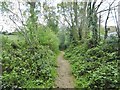
Lytchett Matravers, bridleway
Through grazing land, from Middle Road to Halls Road.
Image: © Mike Faherty
Taken: 19 Apr 2017
0.22 miles
4
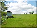
Lytchett Matravers, caravans
Traditional Dorset shepherd's caravans, in a field next to Image
Image: © Mike Faherty
Taken: 19 Apr 2017
0.25 miles