IMAGES TAKEN NEAR TO
Charborough Close, POOLE, BH16 6HE
Introduction
This page details the photographs taken nearby to Charborough Close, BH16 6HE by members of the Geograph project.
The Geograph project started in 2005 with the aim of publishing, organising and preserving representative images for every square kilometre of Great Britain, Ireland and the Isle of Man.

There are currently over 7.5m images from over14,400 individuals and you can help contribute to the project by visiting https://www.geograph.org.uk
Image Map (Loading...)


Getting Data...Please wait
Leaflet Map data © OpenStreetMap
Images are licensed for reuse under creativecommons.org/licenses/by-sa/2.0
Notes
- Clicking on the map will re-center to the selected point.
- The higher the marker number, the further away the image location is from the centre of the postcode.
Image Listing (19 Images Found)
Images are licensed for reuse under creativecommons.org/licenses/by-sa/2.0
Image
Details
Distance
1
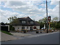
Lytchett Matravers, The Chequers Inn
In High Street; apparently one of the oldest buildings in the village, though few old features remain. Internally, L-shaped bar, with drinking and eating areas on three sides. Cask ales on offer at my visit: Ringwood Best, Wychwood Hobgoblin, St. Austell Tribute. For an old view, see http://www.opcdorset.org/LytchettMatraversFiles/LytchettPhotosOld.htm For some customer comments, see http://www.beerintheevening.com/pubs/s/36/36903/Chequers_Inn/Poole
Image: © Mike Faherty
Taken: 10 May 2010
0.07 miles
2
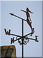
Weather vane, Lytchett Matravers
The word 'vane' comes from the Anglo-Saxon word 'fane', meaning 'flag'. Originally, fabric pennants would show archers the direction of the wind. Later, the cloth flags were replaced by metal ones, decorated with the nobleman's coat of arms. It was understood that shifts in the wind often indicated changes in the weather. Cardinal points were not added until several centuries later.
Weather vanes have always been more than just a wind direction device. Created by skilled craftsman, there is true artistic expression in the varied designs. Initially wood vanes were carved by carpenters or furniture makers, and iron, copper and tin ones were forged by the local blacksmith or tinsmith. In the 19th century weather vanes started to be mass-produced from moulds.
Image: © Maigheach-gheal
Taken: 31 Jan 2010
0.07 miles
3
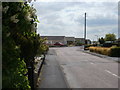
Lytchett Matravers, Old Pound Close
Bungalows off High Street.
Image: © Mike Faherty
Taken: 10 May 2010
0.07 miles
4
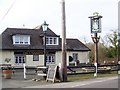
The Chequers Inn, Lytchett Matravers
The pub is undergoing refurbishment.
Image: © Maigheach-gheal
Taken: 31 Jan 2010
0.08 miles
5
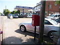
Lytchett Matravers: postbox № BH16 17, High Street
A small postbox serving the western end of the village; it is emptied at 4:30pm on weekdays and at 10am on Saturdays.
Image: © Chris Downer
Taken: 24 May 2009
0.09 miles
6
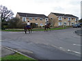
Street scene, Lytchett Matravers
Lychett is a very busy village and it was surprising how many horses and ponies are being ridden along the streets in all directions.
Image: © Maigheach-gheal
Taken: 26 Feb 2011
0.10 miles
7
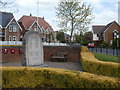
Lytchett Matravers, war memorial
At Higher Cross, on High Street; recording the names of 31 killed in WW1, and 13 in WW2.
Image: © Mike Faherty
Taken: 10 May 2010
0.10 miles
8
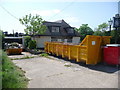
Lytchett Matravers: the Chequers under refurbishment
The Chequers Inn is currently closed for a makeover. Fittingly for a pub of that name, there are some large chess pieces in the skip on the left.
Image: © Chris Downer
Taken: 24 May 2009
0.10 miles
9
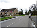
Street scene, Lytchett Matravers
The horse was remarkably good considering the amount of traffic and others things that were going on in streets. There is also a Dorset County Council finger post to the left of the image.
Image: © Maigheach-gheal
Taken: 26 Feb 2011
0.11 miles
10
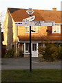
Lytchett Matravers: Higher Cross finger-post
This traditional Dorset signpost retains its original finial, giving location and grid reference details. However, the fingers themselves are modern replacements.
For a close-up of the finial, see Image
Image: © Chris Downer
Taken: 7 Mar 2010
0.11 miles