IMAGES TAKEN NEAR TO
Blandford Road North, POOLE, BH16 6FS
Introduction
This page details the photographs taken nearby to Blandford Road North, BH16 6FS by members of the Geograph project.
The Geograph project started in 2005 with the aim of publishing, organising and preserving representative images for every square kilometre of Great Britain, Ireland and the Isle of Man.

There are currently over 7.5m images from over14,400 individuals and you can help contribute to the project by visiting https://www.geograph.org.uk
Image Map (Loading...)


Getting Data...Please wait
Leaflet Map data © OpenStreetMap
Images are licensed for reuse under creativecommons.org/licenses/by-sa/2.0
Notes
- Clicking on the map will re-center to the selected point.
- The higher the marker number, the further away the image location is from the centre of the postcode.
Image Listing (11 Images Found)
Images are licensed for reuse under creativecommons.org/licenses/by-sa/2.0
Image
Details
Distance
1
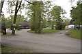
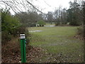
Beacon Hill Touring Park
The building is the Reception area
http://www.beaconhilltouringpark.co.uk/
Image: © John Lamper
Taken: 4 May 2006
0.06 miles
2
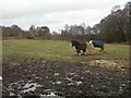
Beacon Hill, grazing
As seen from the access road from Blandford Road North to touring park and sub-station.
Image: © Mike Faherty
Taken: 27 Feb 2010
0.06 miles
3
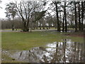
Beacon Hill Touring Park
Fair to say that the owners would not use this image for advertising! The site is currently closed (until Easter), and very wet. Note the many blue power supply posts. http://www.beaconhilltouringpark.co.uk/
Image: © Mike Faherty
Taken: 27 Feb 2010
0.07 miles
4
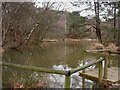
Beacon Hill, fishing lake
One of two lakes on the southern side of Beacon Hill, on Image Shown nearby on old OS maps as pottery and kilns, so presumably the lakes are disused clay pits, common in the area. http://www.beaconhilltouringpark.co.uk/fishing.html
Image: © Mike Faherty
Taken: 27 Feb 2010
0.11 miles
5
Beacon Hill, power supply
One of many power supply posts on Beacon Hill Touring Park. The park is closed until Easter, so pitches are currently empty. http://www.beaconhilltouringpark.co.uk/pitches.html
Image: © Mike Faherty
Taken: 27 Feb 2010
0.12 miles
6
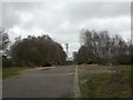
Beacon Hill, telecoms tower
On the access road to Image
Image: © Mike Faherty
Taken: 27 Feb 2010
0.14 miles
7
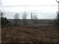
Beacon Hill, sub-station
On the southern side of the hill, with power lines radiating to Sturminster Marshall, Poole and Upton.
Image: © Mike Faherty
Taken: 27 Feb 2010
0.15 miles
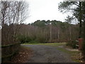
8
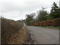
Beacon Hill, access road
Road from Blandford Road North to sub-station and touring park.
Image: © Mike Faherty
Taken: 27 Feb 2010
0.19 miles
9

Beacon Hill, stream
Stream flowing through woodland on the south-eastern side of Image
Image: © Mike Faherty
Taken: 27 Feb 2010
0.19 miles
10
Beacon Hill
Hill between Blandford Road North and Wareham Road; covered in pine, birch and rhododendron. Apparently the site of Lytchett Beacon, though not visible from here.
Image: © Mike Faherty
Taken: 27 Feb 2010
0.24 miles