IMAGES TAKEN NEAR TO
Holton Road, POOLE, BH16 6FL
Introduction
This page details the photographs taken nearby to Holton Road, BH16 6FL by members of the Geograph project.
The Geograph project started in 2005 with the aim of publishing, organising and preserving representative images for every square kilometre of Great Britain, Ireland and the Isle of Man.

There are currently over 7.5m images from over14,400 individuals and you can help contribute to the project by visiting https://www.geograph.org.uk
Image Map (Loading...)


Getting Data...Please wait
Leaflet Map data © OpenStreetMap
Images are licensed for reuse under creativecommons.org/licenses/by-sa/2.0
Notes
- Clicking on the map will re-center to the selected point.
- The higher the marker number, the further away the image location is from the centre of the postcode.
Image Listing (4 Images Found)
Images are licensed for reuse under creativecommons.org/licenses/by-sa/2.0
Image
Details
Distance

2
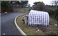
Holton Heath Industrial Estate
Fly-tipping by mini-roundabout on Holton Heath Industrial estate. Holton Heath itself lies beyond the gate.
Image: © John Lamper
Taken: 18 Jan 2006
0.10 miles
3
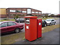
Holton Heath: postbox №s BH16 290 and BH16 512, Holton Road
These two boxes serve this large-ish trading park, the one on the left (number 512) for franked mail and the right-hand one for stamped mail.
The franked mail box is emptied later than the other on weekdays – 6:30pm as opposed to 5:30 – but the stamped mail box receives the later collection on Saturdays – 12:45pm compared with 12:30.
Image: © Chris Downer
Taken: 17 Jan 2009
0.13 miles
4
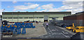
Engineering works, Holton Heath Trading Park
The trading park is between Wareham and Poole. The view is from a passing train.
Image: © Robin Stott
Taken: 15 Aug 2017
0.17 miles