IMAGES TAKEN NEAR TO
Halls Road, POOLE, BH16 6EP
Introduction
This page details the photographs taken nearby to Halls Road, BH16 6EP by members of the Geograph project.
The Geograph project started in 2005 with the aim of publishing, organising and preserving representative images for every square kilometre of Great Britain, Ireland and the Isle of Man.

There are currently over 7.5m images from over14,400 individuals and you can help contribute to the project by visiting https://www.geograph.org.uk
Image Map (9 Images)


Getting Data...Please wait
Leaflet Map data © OpenStreetMap
Images are licensed for reuse under creativecommons.org/licenses/by-sa/2.0
Notes
- Clicking on the map will re-center to the selected point.
- The higher the marker number, the further away the image location is from the centre of the postcode.
Image Listing (9 Images Found)
Images are licensed for reuse under creativecommons.org/licenses/by-sa/2.0
Image
Details
Distance
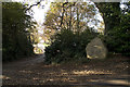
1

Boundary stone near Lytchett Matravers
Although the date is uncertain the parish boundary stone is thought to be 18th century.
Image: © Maigheach-gheal
Taken: 31 Jan 2010
0.08 miles
2
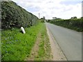
Lytchett Matravers, Halls Road
A straight road connecting Bulbury Lane with Wareham Road, and forming the boundary between Lytchett Matravers (left) and Lytchett Minster (right). To the front is an illegible boundary stone.
Image: © Mike Faherty
Taken: 19 Apr 2017
0.10 miles
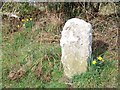
3

Old Boundary Marker on Halls Road
Parish Boundary Marker against a hedge on the north side of Halls Road, 40 metres west of the junction with Middle Road. On the boundary of Lytchett Maltravers and Lychett Minster and Upton parishes. See also https://www.geograph.org.uk/photo/5357566.
Milestone Society National ID: DO_LMALMIN01pb
Image: © M Faherty
Taken: 1 Sep 2007
0.10 miles
4
Boundary stone near Lytchett Matravers
Although the date is uncertain the parish boundary stone is thought to be 18th century. For a wider view see Image
Image: © Maigheach-gheal
Taken: 31 Jan 2010
0.11 miles
5
Farm entrance near Lytchett Matravers, Dorset
A substantial sign that is unlikely to go missing!
Image: © John Lamper
Taken: 20 Nov 2005
0.12 miles
6
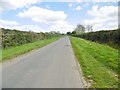
Lytchett Matravers, Middle Road
Leading from Halls Road to the village centre.
Image: © Mike Faherty
Taken: 19 Apr 2017
0.16 miles
7
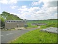
Lytchett Matravers, pumping station
On Halls Road.
Image: © Mike Faherty
Taken: 19 Apr 2017
0.16 miles
8
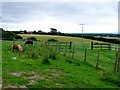
Pony Paddocks near Lytchett Matravers
These paddocks containing shetland ponies are just south of the village near Eddy Green Rd.
Image: © Nigel Mykura
Taken: 12 Aug 2009
0.19 miles
9
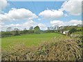
Lytchett Matravers, power lines
Striding across grazing land.
Image: © Mike Faherty
Taken: 19 Apr 2017
0.22 miles