IMAGES TAKEN NEAR TO
Poole Road, POOLE, BH16 6AG
Introduction
This page details the photographs taken nearby to Poole Road, BH16 6AG by members of the Geograph project.
The Geograph project started in 2005 with the aim of publishing, organising and preserving representative images for every square kilometre of Great Britain, Ireland and the Isle of Man.

There are currently over 7.5m images from over14,400 individuals and you can help contribute to the project by visiting https://www.geograph.org.uk
Image Map (Loading...)


Getting Data...Please wait
Leaflet Map data © OpenStreetMap
Images are licensed for reuse under creativecommons.org/licenses/by-sa/2.0
Notes
- Clicking on the map will re-center to the selected point.
- The higher the marker number, the further away the image location is from the centre of the postcode.
Image Listing (5 Images Found)
Images are licensed for reuse under creativecommons.org/licenses/by-sa/2.0
Image
Details
Distance
2
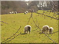
New Sheep
This year's lambs still keeping close to their mothers.
The field is off Sandy Lane, not far from Sandpit Farm.
Image: © Simon Scurr
Taken: 19 Mar 2007
0.19 miles
3
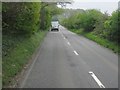
Follow that van!
Poole Road, A350, close to the turning for Woodlands Nurseries.
Image: © Mr Ignavy
Taken: 6 May 2010
0.22 miles
4
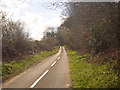
Sandy Lane, Combe Almer
Sandy Lane on a sunny day, just off the A350 Blandford Road.
Image: © Simon Scurr
Taken: 19 Mar 2007
0.23 miles
